IMAGES TAKEN NEAR TO
Lucas Close, QUEENBOROUGH, ME11 5EA
Introduction
This page details the photographs taken nearby to Lucas Close, ME11 5EA by members of the Geograph project.
The Geograph project started in 2005 with the aim of publishing, organising and preserving representative images for every square kilometre of Great Britain, Ireland and the Isle of Man.

There are currently over 7.5m images from over14,400 individuals and you can help contribute to the project by visiting https://www.geograph.org.uk
Image Map
Images are licensed for reuse under creativecommons.org/licenses/by-sa/2.0
Notes
- Clicking on the map will re-center to the selected point.
- The higher the marker number, the further away the image location is from the centre of the postcode.
Image Listing (85 Images Found)
Images are licensed for reuse under creativecommons.org/licenses/by-sa/2.0
Image
Details
Distance
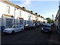
1
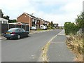
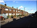
Backs of houses in Mount Field, Queenborough
These were built on the trackbed of The Sheppey Light Railway as it neared its approach to Queenborough railway station. According to http://www.sheppeywebsite.co.uk/index.php?id=95 the railway opened on 1 August 1901 and closed on 4 December 1950. The total length was 8 miles 52 chains. It ran from Queenborough (where there was a north-facing bay platform on the east side of the station) to Leysdown with intermediate stations at Sheerness East, East Minster-on-Sea (which was actually west of Minster), Minster-on-Sea (they're only given as Minster in the link), Brambledown Halt, Eastchurch and Harty Road Halt. Today, one can trace most of the route from the air and on the Ordnance Survey map (Explorer 149). On the ground, one can find sections overgrown with grass, brambles and trees, sections built over, sections concreted over to form a permanent way or landscaped to form paths for pedestrians.
Image: © John Baker
Taken: 26 Jul 2012
0.04 miles
2
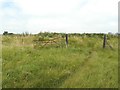
Moat Way, Queenborough
At the far end of the road, one can gain access to the former trackbed of The Sheppey Light Railway which according to http://www.sheppeywebsite.co.uk/index.php?id=95 opened on 1 August 1901 and closed on 4 December 1950. The total length was 8 miles 52 chains. It ran from Queenborough (where there was a north-facing bay platform on the east side of the station) to Leysdown with intermediate stations at Sheerness East, East Minster-on-Sea (which was actually west of Minster), Minster-on-Sea (they're only given as Minster in the link), Brambledown Halt, Eastchurch and Harty Road Halt. Today, one can trace most of the route from the air and on the Ordnance Survey map (Explorer 149). On the ground, one can find sections overgrown with grass, brambles and trees, sections built over, sections concreted over to form a permanent way or landscaped to form paths for pedestrians.
Image: © John Baker
Taken: 26 Jul 2012
0.05 miles
3
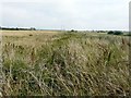
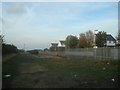
Former trackbed of Sheppey Light Railway
According to http://www.sheppeywebsite.co.uk/index.php?id=95 The Sheppey Light Railway opened on 1 August 1901 and closed on 4 December 1950. The total length was 8 miles 52 chains. It ran from Queenborough (where there was a north-facing bay platform on the east side of the station) to Leysdown with intermediate stations at Sheerness East, East Minster-on-Sea (which was actually west of Minster), Minster-on-Sea (they're only given as Minster in the link), Brambledown Halt, Eastchurch and Harty Road Halt. Today, one can trace most of the route from the air and on the Ordnance Survey map (Explorer 149). On the ground, one can find sections overgrown with grass (as here), brambles and trees, sections built over, sections concreted over to form a permanent way or landscaped to form paths for pedestrians. This view is looking towards Brielle Way. A line of Southern Region concrete fence posts can be seen on the left.
Image: © John Baker
Taken: 26 Jul 2012
0.07 miles
4
Former trackbed of Sheppey Light Railway
According to http://www.sheppeywebsite.co.uk/index.php?id=95 The Sheppey Light Railway opened on 1 August 1901 and closed on 4 December 1950. The total length was 8 miles 52 chains. It ran from Queenborough (where there was a north-facing bay platform on the east side of the station) to Leysdown with intermediate stations at Sheerness East, East Minster-on-Sea (which was actually west of Minster), Minster-on-Sea (they're only given as Minster in the link), Brambledown Halt, Eastchurch and Harty Road Halt. Today, one can trace most of the route from the air and on the Ordnance Survey map (Explorer 149). On the ground, one can find sections overgrown with grass (as here), brambles and trees, sections built over, sections concreted over to form a permanent way or landscaped to form paths for pedestrians. This view is looking from Brielle Way towards Queenborough. A line of Southern Region concrete fence posts can be seen on the left.
Image: © John Baker
Taken: 26 Jul 2012
0.09 miles
5
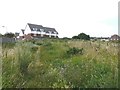
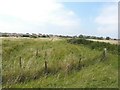
Gate beside former trackbed of Sheppey Light Railway
According to http://www.sheppeywebsite.co.uk/index.php?id=95 The Sheppey Light Railway opened on 1 August 1901 and closed on 4 December 1950. The total length was 8 miles 52 chains. It ran from Queenborough (where there was a north-facing bay platform on the east side of the station) to Leysdown with intermediate stations at Sheerness East, East Minster-on-Sea (which was actually west of Minster), Minster-on-Sea (they're only given as Minster in the link), Brambledown Halt, Eastchurch and Harty Road Halt. Today, one can trace most of the route from the air and on the Ordnance Survey map (Explorer 149). On the ground, one can find sections overgrown with grass, brambles and trees, sections built over, sections concreted over to form a permanent way or landscaped to form paths for pedestrians. At the time when the railway was a going concern, this gate would have been closed to prevent livestock from straying onto the line.
Image: © John Baker
Taken: 26 Jul 2012
0.09 miles
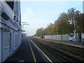
8
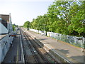
Queenborough station from the footbridge
The line was opened on 19th July 1860 by the Sittingbourne & Sheerness Railway (S&SR), a nominally independent company which had powers to construct a branch line from Sittingbourne across the Swale to a terminus near the entrance of Sheerness Dockyard. The line was worked from the outset by the London, Chatham & Dover Railway which absorbed the S&SR in 1876. Queenborough station opened on the same day.
On 15th May 1876, Queenborough became a junction station with the opening of a short spur to Queenborough Pier to serve steam ship services. A second line was added on 1st August 1901 with the opening of the Sheppey Light Railway across the Isle of Sheppey to Leysdown. The iron footbridge from which this photograph was taken was erected at the southern end of the platforms to facilitate passengers changing between the main line and branch services. Services on the Sheppey Light Railway ceased as from 4th December 1950.
Until the opening of Swale Halt in 1922, Queenborough was the only intermediate station on the Sheerness Line. The line through Queenborough was electrified and the platforms were lengthened in 1959 as part of phase I of the Kent Coast Electrification. This view looks in the direction of Sheerness.
Image: © Marathon
Taken: 28 May 2016
0.11 miles