IMAGES TAKEN NEAR TO
Eastern Avenue, QUEENBOROUGH, ME11 5DR
Introduction
This page details the photographs taken nearby to Eastern Avenue, ME11 5DR by members of the Geograph project.
The Geograph project started in 2005 with the aim of publishing, organising and preserving representative images for every square kilometre of Great Britain, Ireland and the Isle of Man.

There are currently over 7.5m images from over14,400 individuals and you can help contribute to the project by visiting https://www.geograph.org.uk
Image Map
Images are licensed for reuse under creativecommons.org/licenses/by-sa/2.0
Notes
- Clicking on the map will re-center to the selected point.
- The higher the marker number, the further away the image location is from the centre of the postcode.
Image Listing (47 Images Found)
Images are licensed for reuse under creativecommons.org/licenses/by-sa/2.0
Image
Details
Distance
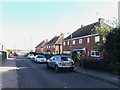
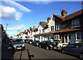
6
Main Road (B2007), Queenborough
The Borough Hall is the large building on the left. It is used for social functions.
Image: © John Baker
Taken: 8 Jan 2012
0.09 miles
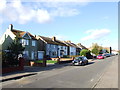
9
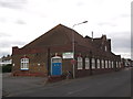
Borough Hall, Queenborough
Large community hall beside the B2007 Main Road (into Queenborough).
Image: © David Anstiss
Taken: 9 Jun 2012
0.10 miles