IMAGES TAKEN NEAR TO
Yevele Close, QUEENBOROUGH, ME11 5BZ
Introduction
This page details the photographs taken nearby to Yevele Close, ME11 5BZ by members of the Geograph project.
The Geograph project started in 2005 with the aim of publishing, organising and preserving representative images for every square kilometre of Great Britain, Ireland and the Isle of Man.

There are currently over 7.5m images from over14,400 individuals and you can help contribute to the project by visiting https://www.geograph.org.uk
Image Map
Images are licensed for reuse under creativecommons.org/licenses/by-sa/2.0
Notes
- Clicking on the map will re-center to the selected point.
- The higher the marker number, the further away the image location is from the centre of the postcode.
Image Listing (95 Images Found)
Images are licensed for reuse under creativecommons.org/licenses/by-sa/2.0
Image
Details
Distance
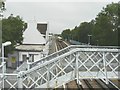
3
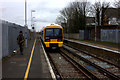
Queenborough station looking northwards
South Eastern 466 unit leaves for Sheerness
Image: © Robert Eva
Taken: 4 Mar 2017
0.04 miles
5

DC electric unit at Queenborough
508025 was one of a few former Merseyrail class 508 units seconded to work in Kent and Surrey for a time until newer stock arrived.
Image: © Stephen Craven
Taken: 3 Jun 2006
0.05 miles
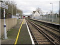
6
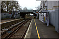
Queenborough Railway Station (former Sheppey Light Railway terminus)
Looking in the direction of Sheerness, this was once the terminus of the former Sheppey Light Railway whose trains departed to Leysdown-on-Sea from the far side of the platform on the right. The Sheppey Light Railway operated from 1901 to 1950.
Image: © Nigel Cox
Taken: 24 Nov 2013
0.05 miles
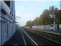
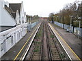
7
Queenborough railway station, Kent
Opened in 1860 on what became the London Chatham & Dover Railway's line from Sittingbourne to Sheerness.
View south towards Swale and Sittingbourne. This was also the terminus for the Sheppey Light Railway from 1901 to 1950, with trains using the platform far left, now behind the fence.
Image: © Nigel Thompson
Taken: 9 Jan 2014
0.05 miles
8
Queenborough railway station
At one time, there was a north-facing bay to the right of the platform the train is approaching (from Sheerness), which was for Sheppey Light Railway trains. According to http://www.sheppeywebsite.co.uk/index.php?id=95 the Sheppey Light Railway opened on 1 August 1901 and closed on 4 December 1950. The total length was 8 miles 52 chains. It ran from Queenborough to Leysdown with intermediate stations at Sheerness East, East Minster-on-Sea (which was actually west of Minster), Minster-on-Sea (they're only given as Minster in the link), Brambledown Halt, Eastchurch and Harty Road Halt. Today, one can trace most of the route from the air and on the Ordnance Survey map (Explorer 149). On the ground, one can find sections overgrown with grass, brambles and trees, sections built over, sections concreted over to form a permanent way or landscaped to form paths for pedestrians.
Image: © John Baker
Taken: 26 Jul 2012
0.05 miles