IMAGES TAKEN NEAR TO
Foxley Road, QUEENBOROUGH, ME11 5AW
Introduction
This page details the photographs taken nearby to Foxley Road, ME11 5AW by members of the Geograph project.
The Geograph project started in 2005 with the aim of publishing, organising and preserving representative images for every square kilometre of Great Britain, Ireland and the Isle of Man.

There are currently over 7.5m images from over14,400 individuals and you can help contribute to the project by visiting https://www.geograph.org.uk
Image Map
Images are licensed for reuse under creativecommons.org/licenses/by-sa/2.0
Notes
- Clicking on the map will re-center to the selected point.
- The higher the marker number, the further away the image location is from the centre of the postcode.
Image Listing (109 Images Found)
Images are licensed for reuse under creativecommons.org/licenses/by-sa/2.0
Image
Details
Distance
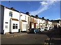
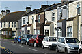
2
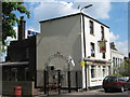
The Rose Inn, Queenborough
On 80 High Street.
Image: © David Anstiss
Taken: 26 Apr 2009
0.10 miles
6
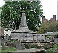
Holy Trinity, Queenborough, Kent - Churchyard
Image: © John Salmon
Taken: 27 Apr 2002
0.13 miles
10
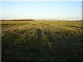
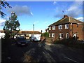
Pasture east of the B2007
The elevated section of road in the distance is the A249 where it crosses the railway obliquely.
Image: © Penny Mayes
Taken: 21 Jan 2006
0.15 miles