IMAGES TAKEN NEAR TO
Ledger Close, SITTINGBOURNE, ME10 5BT
Introduction
This page details the photographs taken nearby to Ledger Close, ME10 5BT by members of the Geograph project.
The Geograph project started in 2005 with the aim of publishing, organising and preserving representative images for every square kilometre of Great Britain, Ireland and the Isle of Man.

There are currently over 7.5m images from over14,400 individuals and you can help contribute to the project by visiting https://www.geograph.org.uk
Image Map
Images are licensed for reuse under creativecommons.org/licenses/by-sa/2.0
Notes
- Clicking on the map will re-center to the selected point.
- The higher the marker number, the further away the image location is from the centre of the postcode.
Image Listing (44 Images Found)
Images are licensed for reuse under creativecommons.org/licenses/by-sa/2.0
Image
Details
Distance
1
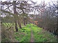
Footpath to Milton Regis
This path leads from Sheppey Way, Bobbing, alongside the London to
Sittingbourne railway line (on the right), then through a community woodland, before reaching the B2006 (in Milton Regis).
Image: © David Anstiss
Taken: 22 Mar 2012
0.04 miles
2
Footpath and road bridges, Bobbing
This path leads from the B2006 (in Milton Regis) through a community woodland, and then alongside the Sittingbourne to London railway line (on the left), before heading under the A249 Dual Carriageway.
Before the A249,is a level crossing on a path leading towards Key Street.
In the background is Sheppey Way road bridge.
B
Image: © David Anstiss
Taken: 22 Mar 2012
0.06 miles
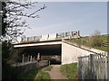
3
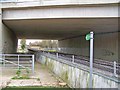
Footpath and railway under new bridge
Looking east south east, the footpath connects Bobbing to Sittingbourne. The bridge carries the A249 dual carriageway.
Image: © Richard Dorrell
Taken: 3 Feb 2008
0.07 miles
4
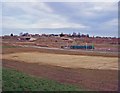
Office development site, near Sittingbourne
Once this development site has been filled in, there will be no open space between Bobbing and Sittingbourne.
Image: © Richard Dorrell
Taken: 3 Feb 2008
0.08 miles
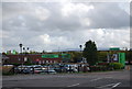
5
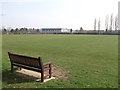
Rugby field, Grove Park Community School
As seen from close to a footpath between Milton Regis and Key Street.
Image: © David Anstiss
Taken: 22 Mar 2012
0.09 miles
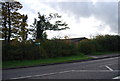
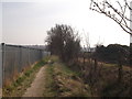
7
Footpath to Grove Park
This surprisingly rural-looking footpath runs close to the A249 dual carriageway between Bobbing and Key Street.
Image: © Richard Dorrell
Taken: 3 Feb 2008
0.11 miles
8
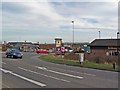
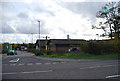
Fast food outlets
On a small patch of land in Bobbing "cut off" by the building of a dual carriageway bypass, this food retail park has been built. The pub is imaginatively named the "Bobbing Apple".
Image: © Richard Dorrell
Taken: 3 Feb 2008
0.12 miles