IMAGES TAKEN NEAR TO
High Street, SITTINGBOURNE, ME10 4PE
Introduction
This page details the photographs taken nearby to High Street, ME10 4PE by members of the Geograph project.
The Geograph project started in 2005 with the aim of publishing, organising and preserving representative images for every square kilometre of Great Britain, Ireland and the Isle of Man.

There are currently over 7.5m images from over14,400 individuals and you can help contribute to the project by visiting https://www.geograph.org.uk
Image Map
Images are licensed for reuse under creativecommons.org/licenses/by-sa/2.0
Notes
- Clicking on the map will re-center to the selected point.
- The higher the marker number, the further away the image location is from the centre of the postcode.
Image Listing (120 Images Found)
Images are licensed for reuse under creativecommons.org/licenses/by-sa/2.0
Image
Details
Distance
3
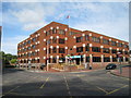
Swale House, East Street, Sittingbourne, Kent
Image: © Oast House Archive
Taken: 17 Aug 2008
0.01 miles
4
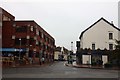
East Street in Sittingbourne
The picture is taken from High Street looking across Crown Quay Lane.
Image: © Steve Daniels
Taken: 11 Oct 2012
0.02 miles
5
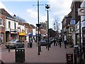
High Street, Sittingbourne towards St Michael's Church
Image: © John Salmon
Taken: 21 Mar 2007
0.02 miles
6
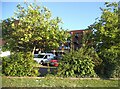
Offices on St Michael's Road, Sittingbourne
Image: © David Howard
Taken: 17 Jul 2016
0.02 miles
8
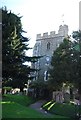
Church of St Michael
Grade II* listed. http://www.britishlistedbuildings.co.uk/en-175786-church-of-st-michael-sittingbourne
Image: © N Chadwick
Taken: 22 Apr 2012
0.03 miles

10

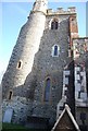
St Michael, Sittingbourne, Kent - East end
Image: © John Salmon
Taken: 15 Mar 2006
0.03 miles