IMAGES TAKEN NEAR TO
Nutfields, SITTINGBOURNE, ME10 4JP
Introduction
This page details the photographs taken nearby to Nutfields, ME10 4JP by members of the Geograph project.
The Geograph project started in 2005 with the aim of publishing, organising and preserving representative images for every square kilometre of Great Britain, Ireland and the Isle of Man.

There are currently over 7.5m images from over14,400 individuals and you can help contribute to the project by visiting https://www.geograph.org.uk
Image Map
Images are licensed for reuse under creativecommons.org/licenses/by-sa/2.0
Notes
- Clicking on the map will re-center to the selected point.
- The higher the marker number, the further away the image location is from the centre of the postcode.
Image Listing (14 Images Found)
Images are licensed for reuse under creativecommons.org/licenses/by-sa/2.0
Image
Details
Distance
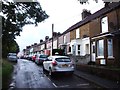
6
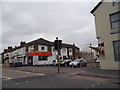
Canterbury Road, Sittingbourne
Bayford Road is on the right but is closed to traffic.
Image: © David Howard
Taken: 19 Jun 2016
0.20 miles
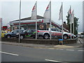
7
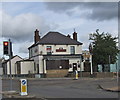
The Prince of Wales Public House, Snipeshill
On traffic light junction of Canterbury Road (A2) and Murston Road.
Image: © David Anstiss
Taken: 5 Nov 2008
0.20 miles
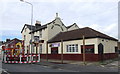
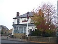
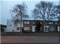
8
The Cherry Tree Public House, Sittingbourne
On junction of Canterbury Road (A2) and Bayford Road.
Image: © David Anstiss
Taken: 5 Nov 2008
0.21 miles
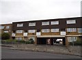
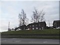
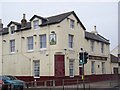
10
Houses on Canterbury Road, Snipeshill
Image: © David Howard
Taken: 19 Mar 2017
0.21 miles