IMAGES TAKEN NEAR TO
Cromers Road, SITTINGBOURNE, ME10 4HP
Introduction
This page details the photographs taken nearby to Cromers Road, ME10 4HP by members of the Geograph project.
The Geograph project started in 2005 with the aim of publishing, organising and preserving representative images for every square kilometre of Great Britain, Ireland and the Isle of Man.

There are currently over 7.5m images from over14,400 individuals and you can help contribute to the project by visiting https://www.geograph.org.uk
Image Map
Images are licensed for reuse under creativecommons.org/licenses/by-sa/2.0
Notes
- Clicking on the map will re-center to the selected point.
- The higher the marker number, the further away the image location is from the centre of the postcode.
Image Listing (14 Images Found)
Images are licensed for reuse under creativecommons.org/licenses/by-sa/2.0
Image
Details
Distance
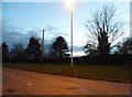
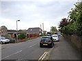
5
Cromers Road
This road runs between two of the three huge disused chalk pits - hence the straightness of it.
Image: © Penny Mayes
Taken: 12 May 2005
0.13 miles
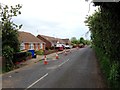
6

Disused Chalk Pit
One of three huge pits in the area, unused for many years they have become a haven for wildlife, flora and fauna. An ancient burial ground was found here.
Image: © Penny Mayes
Taken: 12 May 2005
0.14 miles
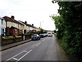
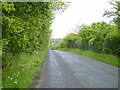
7
Cromer Road
Cromer Road here leads from Tunstall to Highsted. There are disused quarries either side of the road which are now largely wooded.
Image: © Marathon
Taken: 29 May 2016
0.14 miles
8
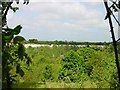
Disused Chalk Pit
One of three huge disused chalk pits in the area which now provide a haven for flora and fauna. The Isle of Sheppey is visible on the horizon.
Image: © Penny Mayes
Taken: 12 May 2005
0.15 miles
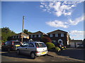
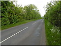
9

Bend on Tunstall Road
The higher wall has been built since 2009
Image: © David Howard
Taken: 17 Jul 2016
0.15 miles