IMAGES TAKEN NEAR TO
Central Avenue, SITTINGBOURNE, ME10 4BX
Introduction
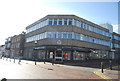
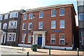
This page details the photographs taken nearby to Central Avenue, ME10 4BX by members of the Geograph project.
The Geograph project started in 2005 with the aim of publishing, organising and preserving representative images for every square kilometre of Great Britain, Ireland and the Isle of Man.

There are currently over 7.5m images from over14,400 individuals and you can help contribute to the project by visiting https://www.geograph.org.uk
Image Map
Images are licensed for reuse under creativecommons.org/licenses/by-sa/2.0
Notes
- Clicking on the map will re-center to the selected point.
- The higher the marker number, the further away the image location is from the centre of the postcode.
Image Listing (179 Images Found)
Images are licensed for reuse under creativecommons.org/licenses/by-sa/2.0
Image
Details
Distance
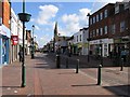
4
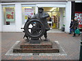
Statue 'The Bargerman' in London Road, Sittingbourne
Image: © PAUL FARMER
Taken: 8 Jan 2011
0.03 miles
6
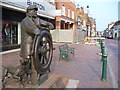
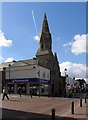
"The Bargee", Sittingbourne High Street
This Kentish town sits at the head of a navigable (at high tide) Thames-side creek. The High Street is the long and straight Watling Street, the old Roman road from Dover to London. This later became a coaching route.
Image: © Colin Smith
Taken: 29 Apr 2007
0.03 miles
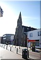
9
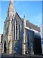
United Reformed Church, Sittingbourne
On the High Street.
Image: © David Anstiss
Taken: 4 Jun 2011
0.03 miles
