IMAGES TAKEN NEAR TO
High Street, SITTINGBOURNE, ME10 4AP
Introduction
This page details the photographs taken nearby to High Street, ME10 4AP by members of the Geograph project.
The Geograph project started in 2005 with the aim of publishing, organising and preserving representative images for every square kilometre of Great Britain, Ireland and the Isle of Man.

There are currently over 7.5m images from over14,400 individuals and you can help contribute to the project by visiting https://www.geograph.org.uk
Image Map
Images are licensed for reuse under creativecommons.org/licenses/by-sa/2.0
Notes
- Clicking on the map will re-center to the selected point.
- The higher the marker number, the further away the image location is from the centre of the postcode.
Image Listing (159 Images Found)
Images are licensed for reuse under creativecommons.org/licenses/by-sa/2.0
Image
Details
Distance
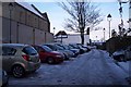
1
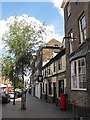
South side of Sittingbourne High Street
The bow window on the right belongs to the Kent Messenger (local newspaper) office. The pub next door is called The George and Dragon in this photo although from the Google streetview for May 2009 I see it was called The Entertainer. I have a vague recollection of it as The George (but that may have been elsewhere on the street).
Streetview also shows me that the next shop down has suffered a fire at some point which may explain the hole in the roof (which was what prompted me to take this photo).
The colonnaded entrance below it is Blundell's furniture store. I remember a time, not so long ago, when Mr Blundell had three shops on the High Street, the furniture store, a baby shop and a rather wonderful toy shop. I was hoping to visit the toy shop on this visit but sad to say it had closed down. Had I checked streetview first I'd have known this.
Image: © Penny Mayes
Taken: 28 May 2010
0.01 miles
2
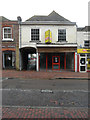
30, High Street
These premises used to be a restaurant/café.
Image: © John Baker
Taken: 2 Dec 2018
0.02 miles
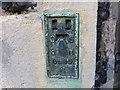
3
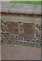
Old Milestone, Former A2, High Street, Sittingbourne
The milestone is located at the south west corner of St Michael's Churchyard, in the pedestrian zone, set in the end of the flint retaining wall round the graveyard, on the north side of the road. Parish of Sittingbourne (Swale District). Metal plates detached from post, Dover Road facet design, erected by the Chatham & Canterbury turnpike trust in the 19th century.
Inscriptions read:-
40 / MILES / TO / LONDON : : 15 / MILES / TO / CANTERBURY
Milestone Society National ID: KE_LD40
Image: © C Woodward
Taken: 17 Jul 2007
0.03 miles
5
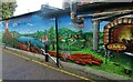
"Fireaway Pizza", Sittingbourne
Mural at the side of this takeaway restaurant in Grafton Road.
Image: © pam fray
Taken: 31 Jan 2022
0.03 miles
6
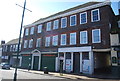
35 - 39 High St
Grade II listed. http://www.britishlistedbuildings.co.uk/en-175773-35-39-sittingbourne
Image: © N Chadwick
Taken: 22 Apr 2012
0.03 miles
7
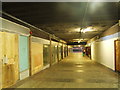
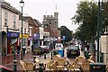
The Bell Shopping Centre, Sittingbourne
Image: © Chris Whippet
Taken: 15 Aug 2013
0.03 miles
8
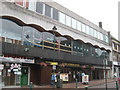
The Summoner Public house, Sittingbourne
Wetherspoon public house on the high street under a snooker club.
Was once shops as part of the Bell Shopping Centre.
Image: © David Anstiss
Taken: 16 Jul 2011
0.04 miles
9
Grafton Road, Sittingbourne
This road and alley leads from the Sittingbourne High Street to St.Michaels Road. On the left is the Methodist Church.
Image: © David Anstiss
Taken: 17 Dec 2009
0.05 miles
10
Ordnance Survey Flush Bracket S0690
This can be found on the wall of St Michaels parish Church in Sittingbourne,
For more detail see : http://www.bench-marks.org.uk/bm2566
Image: © Peter Wood
Taken: 18 Feb 2016
0.05 miles