IMAGES TAKEN NEAR TO
St. Michaels Close, SITTINGBOURNE, ME10 3DH
Introduction
This page details the photographs taken nearby to St. Michaels Close, ME10 3DH by members of the Geograph project.
The Geograph project started in 2005 with the aim of publishing, organising and preserving representative images for every square kilometre of Great Britain, Ireland and the Isle of Man.

There are currently over 7.5m images from over14,400 individuals and you can help contribute to the project by visiting https://www.geograph.org.uk
Image Map
Images are licensed for reuse under creativecommons.org/licenses/by-sa/2.0
Notes
- Clicking on the map will re-center to the selected point.
- The higher the marker number, the further away the image location is from the centre of the postcode.
Image Listing (161 Images Found)
Images are licensed for reuse under creativecommons.org/licenses/by-sa/2.0
Image
Details
Distance

2

St Michael, Sittingbourne, Kent - East window
The Last Supper
Image: © John Salmon
Taken: 15 Mar 2006
0.03 miles

4

Sittingbourne fire station
Sittingbourne fire station, St Michaels Road, Sittingbourne, Kent
Image: © Kevin Hale
Taken: 27 Apr 2009
0.04 miles
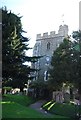
5

St Michael, Sittingbourne, Kent - East end
Image: © John Salmon
Taken: 15 Mar 2006
0.04 miles

7
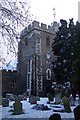
St Michael's Church, Winter 2009
Seen from an alley through the churchyard from the car park on St.Michael's Road to the High Street.
Image: © David Anstiss
Taken: 17 Dec 2009
0.04 miles
8
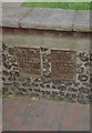
Old Milestone, Former A2, High Street, Sittingbourne
The milestone is located at the south west corner of St Michael's Churchyard, in the pedestrian zone, set in the end of the flint retaining wall round the graveyard, on the north side of the road. Parish of Sittingbourne (Swale District). Metal plates detached from post, Dover Road facet design, erected by the Chatham & Canterbury turnpike trust in the 19th century.
Inscriptions read:-
40 / MILES / TO / LONDON : : 15 / MILES / TO / CANTERBURY
Milestone Society National ID: KE_LD40
Image: © C Woodward
Taken: 17 Jul 2007
0.05 miles
10
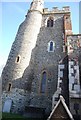
Church of St Michael
Grade II* listed. http://www.britishlistedbuildings.co.uk/en-175786-church-of-st-michael-sittingbourne
Image: © N Chadwick
Taken: 22 Apr 2012
0.05 miles