IMAGES TAKEN NEAR TO
Church Street, SITTINGBOURNE, ME10 2WS
Introduction
This page details the photographs taken nearby to Church Street, ME10 2WS by members of the Geograph project.
The Geograph project started in 2005 with the aim of publishing, organising and preserving representative images for every square kilometre of Great Britain, Ireland and the Isle of Man.

There are currently over 7.5m images from over14,400 individuals and you can help contribute to the project by visiting https://www.geograph.org.uk
Image Map
Images are licensed for reuse under creativecommons.org/licenses/by-sa/2.0
Notes
- Clicking on the map will re-center to the selected point.
- The higher the marker number, the further away the image location is from the centre of the postcode.
Image Listing (177 Images Found)
Images are licensed for reuse under creativecommons.org/licenses/by-sa/2.0
Image
Details
Distance

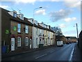
4
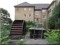
Watermill Mews, Sittingbourne
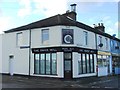
Large block of housing on Church Street beside Periwinkle Close.
The watermill is from a 400 year old watermill. The Periwinkle Museum Trust is restoring the watermill and workings. The watermill used to run on a stream leading to the papermill.
Image: © David Anstiss
Taken: 31 May 2012
0.05 miles
7
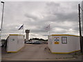
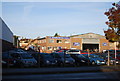
Entrance to Milton Way Building site, Sittingbourne
This entrance on Church Street, is for all the contractors working on the former paper mill site.
Current proposals are for a large supermarket (Morrisons) and petrol garage and several new houses.
If planning is agreed. The former mill water tower will stay as a 'feature'
See http://www.sittingbournemill.com/proposal.html for more details about the development.
Image: © David Anstiss
Taken: 31 May 2012
0.06 miles
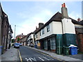
10
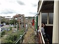
Sittingbourne - 2015
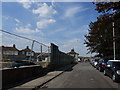
Sittingbourne, Kent, Sittingbourne Steam Railway aka Sittingbourne & Kemsley Light Railway (S&KLR), Sittingbourne Viaduct
Image: © Helmut Zozmann
Taken: 29 Jul 2015
0.08 miles