IMAGES TAKEN NEAR TO
Mercury Close, ME10 2WJ
Introduction
This page details the photographs taken nearby to Mercury Close, ME10 2WJ by members of the Geograph project.
The Geograph project started in 2005 with the aim of publishing, organising and preserving representative images for every square kilometre of Great Britain, Ireland and the Isle of Man.

There are currently over 7.5m images from over14,400 individuals and you can help contribute to the project by visiting https://www.geograph.org.uk
Image Map
Images are licensed for reuse under creativecommons.org/licenses/by-sa/2.0
Notes
- Clicking on the map will re-center to the selected point.
- The higher the marker number, the further away the image location is from the centre of the postcode.
Image Listing (165 Images Found)
Images are licensed for reuse under creativecommons.org/licenses/by-sa/2.0
Image
Details
Distance
1
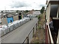
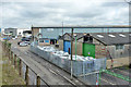
Redevelopment site, off Mill Way, Sittingbourne
Once the Milton Pipes works. Now to be the Watling Gate housing estate.
Image: © Christine Johnstone
Taken: 1 Aug 2018
0.01 miles
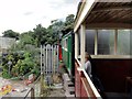
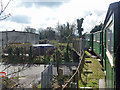
2
Sittingbourne and Kemsley Light Railway over Gas Rd
Image: © N Chadwick
Taken: 30 Oct 2010
0.05 miles
3
Sittingbourne - 2015
Sittingbourne, Kent, Sittingbourne Steam Railway aka Sittingbourne & Kemsley Light Railway (S&KLR), Gas Road
Image: © Helmut Zozmann
Taken: 29 Jul 2015
0.05 miles
4
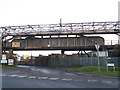
SKLR bridge over Gas Road (south)
Sittingbourne and Kemsley Light Railway, a conservation steam railway line goes from Sittingbourne to Kemsley Down, near papermill. Currently under threat of closure, due to papermill closure. See http://www.sklr.net for more details.
Mill Road (in front) and Gas Road also part of the Saxon Shore Way (long distance path) from Sittingbourne to Kemsley.
Image: © David Anstiss
Taken: 4 Dec 2008
0.05 miles
5
Waste processing works
'White goods' are arrayed in the near corner of the premises. Viewed from a train on the Sittingbourne and Kemsley Light Railway, here on a viaduct.
Image: © Robin Webster
Taken: 4 Apr 2015
0.05 miles
6
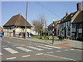
The Court Hall, Milton Regis
Built around 1450.
Image: © Penny Mayes
Taken: 20 Apr 2005
0.06 miles
7
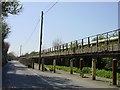
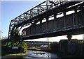
Light railway viaduct and steam pipe, Sittingbourne
The light railway line was built to carry both raw materials and finished paper products between Bowater's paper mills at Sittingbourne and Kemsley. It runs on this low concrete viaduct which has been decaying steadily over the years. The railway line is kept open by a group of enthusiasts who run steam trains on it through the summer http://www.sklr.net/ and have done a lot of work in recent years to maintain the viaduct.
Image: © Penny Mayes
Taken: 20 Apr 2005
0.06 miles
8

Yellow Poles on Gas Road
Here are the yellow poles on the perfect not so perfect Gas Road. They are placed there to protect the light railway from cars and also create bays for cars to give way.
Image: © Joe White
Taken: 14 Oct 2008
0.06 miles
9
Sittingbourne - 2015
Sittingbourne, Kent, Sittingbourne Steam Railway aka Sittingbourne & Kemsley Light Railway (S&KLR), Gas Road
Image: © Helmut Zozmann
Taken: 29 Jul 2015
0.06 miles
10
Train crossing bridge over Gas Road
Viewed from a train on the Sittingbourne and Kemsley Light Railway, here on a viaduct. The railway formerly connected the Bowaters mills at Sittingbourne and at Kemsley, but only the Kemsley mill has survived, under another name.
Image: © Robin Webster
Taken: 4 Apr 2015
0.06 miles