IMAGES TAKEN NEAR TO
Vaughan Drive, SITTINGBOURNE, ME10 2UB
Introduction
This page details the photographs taken nearby to Vaughan Drive, ME10 2UB by members of the Geograph project.
The Geograph project started in 2005 with the aim of publishing, organising and preserving representative images for every square kilometre of Great Britain, Ireland and the Isle of Man.

There are currently over 7.5m images from over14,400 individuals and you can help contribute to the project by visiting https://www.geograph.org.uk
Image Map (Loading...)


Getting Data...Please wait
Leaflet Map data © OpenStreetMap
Images are licensed for reuse under creativecommons.org/licenses/by-sa/2.0
Notes
- Clicking on the map will re-center to the selected point.
- The higher the marker number, the further away the image location is from the centre of the postcode.
Image Listing (70 Images Found)
Images are licensed for reuse under creativecommons.org/licenses/by-sa/2.0
Image
Details
Distance
3
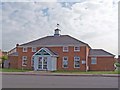
The Clock Tower Hall, Adisham Green
This community hall was built for the community amid the Adisham Green estate. It is in constant use.
Image: © Richard Dorrell
Taken: 4 Apr 2008
0.08 miles
4
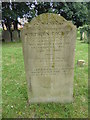
Gravestone in Holy Trinity Churchyard, Milton Regis
Large parts of the church date from the 14th century, including the tower. It also has a very large and interesting churchyard including a number of gravestones dating back to the first half of the 18th century. This gravestone from the mid-19th century is very interesting. Stephen Court was for many years a coal merchant. The rhyme says:
"Think nothing strange
Death will arrest you all
My lot it is to day
To morrow yours may fall"
The oldest part of the church is a Roman wall from the second century CE. The original church building dates to 650 CE with additions in the 11th and 14th centuries. The tower is said to be the largest in Kent and the third largest tower in England. The church is Grade I Listed.
Image: © Marathon
Taken: 27 Jun 2020
0.09 miles
5
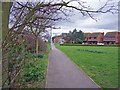
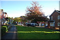
Old footpath, new style
Before the housing estate was built, a footpath connected Holy Trinity Church in Milton Regis to Kemsley village. The line of the footpath has been retained among the housing. The church is just to the right of the end of the footpath.
Image: © Richard Dorrell
Taken: 2 Mar 2008
0.09 miles
7
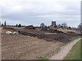
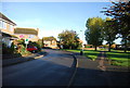
Church Marshes Country Park - nearly there
Massive quantities of material have been used to "cover up" the former landfill site and create the new country park. The path in the picture used to run along the top of a three-metre high flood bund. Now, the "reclaimed" park is level with, and even higher than, the path. The church is Holy Trinity, Milton Regis.
Image: © Richard Dorrell
Taken: 2 Mar 2008
0.09 miles
8
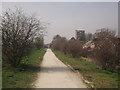
Footpath beside Church Milton Estate (3)
This path leads on a earthwork embankment through the Milton Creek Country Park. The embankment protects the housing from the flooding of Church Marshes (on the left), by the Milton Creek. The path leads from Recreation Way to Green Porch Close and Holy Trinity Church (in the background).
The trees on the left hide a children's play park.
Image: © David Anstiss
Taken: 22 Mar 2012
0.09 miles
9
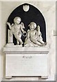
Holy Trinity Church, Milton Regis, Kent - Monument
Image: © John Salmon
Taken: 16 Apr 2008
0.10 miles
10
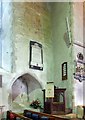
Holy Trinity Church, Milton Regis, Kent
Image: © John Salmon
Taken: 16 Apr 2008
0.10 miles