IMAGES TAKEN NEAR TO
Colfe Way, SITTINGBOURNE, ME10 2TF
Introduction
This page details the photographs taken nearby to Colfe Way, ME10 2TF by members of the Geograph project.
The Geograph project started in 2005 with the aim of publishing, organising and preserving representative images for every square kilometre of Great Britain, Ireland and the Isle of Man.

There are currently over 7.5m images from over14,400 individuals and you can help contribute to the project by visiting https://www.geograph.org.uk
Image Map
Images are licensed for reuse under creativecommons.org/licenses/by-sa/2.0
Notes
- Clicking on the map will re-center to the selected point.
- The higher the marker number, the further away the image location is from the centre of the postcode.
Image Listing (52 Images Found)
Images are licensed for reuse under creativecommons.org/licenses/by-sa/2.0
Image
Details
Distance
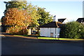
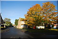
3
Edyngham Close off Newman Drive, Kemsley
Image: © N Chadwick
Taken: 30 Oct 2010
0.05 miles
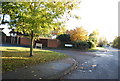
7
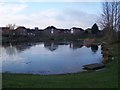
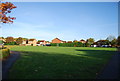
Newman Drive Pond In Church Milton Estate
This pond is surrounded by houses. Todd Crescent leads to the left and Newman Drive (unseen) is on the right. In the background is the steeple of Holy Trinity Church.
Image: © David Anstiss
Taken: 25 Dec 2009
0.08 miles
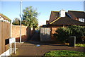
8
Pond incorporated into housing development
Near Kemsley paper mill.
Image: © Penny Mayes
Taken: 20 Apr 2005
0.08 miles
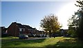
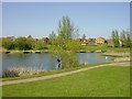
10
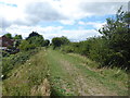
Embankment on Milton Creek Country Park
Milton Creek Country Park consists of 128 acres of a former landfill site. The physical work of developing the Country Park actually began in 2003 with the capping of the landfill site. For more information about the Country Park see the website for https://miltoncreek.co.uk/
There is a Friends of Milton Creek - see https://miltoncreek.co.uk/about/the-friends/
This photograph is taken looking along a high bank which arcs round on the inner edge of the Country Park. The houses on the left are on Beauvoir Drive.
Image: © Marathon
Taken: 27 Jun 2020
0.10 miles