IMAGES TAKEN NEAR TO
Gas Road, SITTINGBOURNE, ME10 2QB
Introduction
This page details the photographs taken nearby to Gas Road, ME10 2QB by members of the Geograph project.
The Geograph project started in 2005 with the aim of publishing, organising and preserving representative images for every square kilometre of Great Britain, Ireland and the Isle of Man.

There are currently over 7.5m images from over14,400 individuals and you can help contribute to the project by visiting https://www.geograph.org.uk
Image Map
Images are licensed for reuse under creativecommons.org/licenses/by-sa/2.0
Notes
- Clicking on the map will re-center to the selected point.
- The higher the marker number, the further away the image location is from the centre of the postcode.
Image Listing (81 Images Found)
Images are licensed for reuse under creativecommons.org/licenses/by-sa/2.0
Image
Details
Distance
1
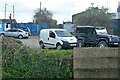
Entrance to car breakers yard
Viewed from a train on the Sittingbourne and Kemsley Light Railway.
Image: © Robin Webster
Taken: 4 Apr 2015
0.04 miles
2
Sittingbourne Household Waste Recycling Centre
Image: © Chris Whippet
Taken: 8 Aug 2013
0.05 miles
3
Sittingbourne - 2015
Sittingbourne, Kent, Sittingbourne Steam Railway aka Sittingbourne & Kemsley Light Railway (S&KLR), former Milton Regis Halt (The Railway Station was closed due to extensive vandalism)
Image: © Helmut Zozmann
Taken: 29 Jul 2015
0.07 miles
4
Sittingbourne - 2015
Sittingbourne, Kent, Sittingbourne Steam Railway aka Sittingbourne & Kemsley Light Railway (S&KLR), Gas Road
Image: © Helmut Zozmann
Taken: 29 Jul 2015
0.07 miles
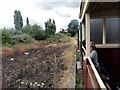
5
Milton Regis Halt
This is the intermediate station between Kemsley Down and Sittingbourne Viaduct on the SKLR heritage railway. The entrance to this station is in the nearby Asda car park.
Image: © David Kemp
Taken: 22 Aug 2012
0.08 miles
6
Entrance to Milton Regis Halt
This station is the intermediate stop between Kemsley Down and Sittingbourne Viaduct on the Sittingbourne & Kemsley Light Railway, a local heritage line.
The entrance is situated in the Asda car park but the station itself is in the next gridsquare (TQ9164).
Image: © David Kemp
Taken: 22 Aug 2012
0.09 miles
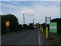
7
Access road to industrial premises by railway viaduct
Viewed from a train on the Sittingbourne and Kemsley Light Railway.
Image: © Robin Webster
Taken: 4 Apr 2015
0.11 miles
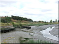
8
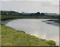
Milton Creek
From the West side of the Saxon Shore way walk. Pleasant walk for a left-over chicken sandwich.
Image: © Joe White
Taken: 17 Jun 2008
0.11 miles
9
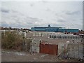
Milton Pipes factory
You are likely to have seen large precast concrete pipes with the name "Milton" stencilled on them. This is where they are made and stored.
Milton Precast is the largest independent manufacturer of precast concrete drainage products in the UK. They offer a full range of precast concrete drainage products including concrete manholes, concrete gullies, concrete inspection chambers and concrete box culverts.
Update: The factory was closed in the summer of 2014.
Image: © Richard Dorrell
Taken: 24 Mar 2008
0.11 miles