IMAGES TAKEN NEAR TO
Staplehurst Road, SITTINGBOURNE, ME10 2NH
Introduction
This page details the photographs taken nearby to Staplehurst Road, ME10 2NH by members of the Geograph project.
The Geograph project started in 2005 with the aim of publishing, organising and preserving representative images for every square kilometre of Great Britain, Ireland and the Isle of Man.

There are currently over 7.5m images from over14,400 individuals and you can help contribute to the project by visiting https://www.geograph.org.uk
Image Map
Images are licensed for reuse under creativecommons.org/licenses/by-sa/2.0
Notes
- Clicking on the map will re-center to the selected point.
- The higher the marker number, the further away the image location is from the centre of the postcode.
Image Listing (33 Images Found)
Images are licensed for reuse under creativecommons.org/licenses/by-sa/2.0
Image
Details
Distance
1
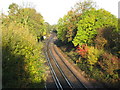
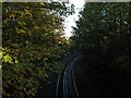
Railway to London
As seen from Image
This line leads from Faversham (via Sittingbourne) towards London.
In the background is a railway junction, the Sheerness line joins the railway to London. This was once used by freight traffic from Sheerness Docks.
Image: © David Anstiss
Taken: 30 Oct 2010
0.03 miles
3
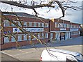
Period factory frontage
The businesses here are involved in logistics and packing and wrapping. The frontage of the building has a pleasing symmetrical look.
Image: © Richard Dorrell
Taken: 21 Mar 2008
0.08 miles
4
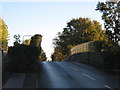
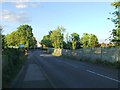
Staplehurst Road Bridge
This road (and footbridge - on the left) leads over the London bound railway line. The road leads from the A2 London Road towards Hythe Road.
Image: © David Anstiss
Taken: 30 Oct 2010
0.08 miles
6
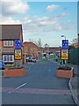
Cavell Way - Children at Play
An attempt at children-friendly traffic calming.
Image: © Richard Dorrell
Taken: 21 Mar 2008
0.11 miles
7
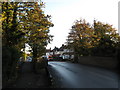
Staplehurst Road bridge (over Sheerness line)
This road leads from the A2 London Road towards Hythe Road.
The road and footbridge leads over the railway between Sittingbourne and Sheerness (on the Isle of Sheppey).
Image: © David Anstiss
Taken: 30 Oct 2010
0.12 miles
8
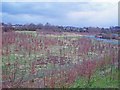
Newly planted woodland, Sittingbourne
To the north west of the original town, Sittingbourne has now merged with neighbouring villages of Milton Regis and Bobbing. New housing and offices are still being built in this area. Some green space has been preserved, however. Here an area of former wasteland has been planted with trees. Many of the trees are oaks, which have retained their brown leaves throughout the winter.
Image: © Richard Dorrell
Taken: 21 Mar 2008
0.12 miles
9
Railway to Sheerness
As seen from Image
This line leads from Sittingbourne towards Sheerness (on the Isle of Sheppey), via Kemsley, Queenborough.
Image: © David Anstiss
Taken: 30 Oct 2010
0.12 miles
10
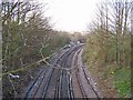
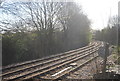
Branch line from Sittingbourne to Sheerness
A minor railway junction is a feature of this gridsquare. This photo is taken looking north from a bridge in Staplehurst Road.
Image: © Richard Dorrell
Taken: 21 Mar 2008
0.12 miles