IMAGES TAKEN NEAR TO
Hythe Road, SITTINGBOURNE, ME10 2LW
Introduction
This page details the photographs taken nearby to Hythe Road, ME10 2LW by members of the Geograph project.
The Geograph project started in 2005 with the aim of publishing, organising and preserving representative images for every square kilometre of Great Britain, Ireland and the Isle of Man.

There are currently over 7.5m images from over14,400 individuals and you can help contribute to the project by visiting https://www.geograph.org.uk
Image Map
Images are licensed for reuse under creativecommons.org/licenses/by-sa/2.0
Notes
- Clicking on the map will re-center to the selected point.
- The higher the marker number, the further away the image location is from the centre of the postcode.
Image Listing (51 Images Found)
Images are licensed for reuse under creativecommons.org/licenses/by-sa/2.0
Image
Details
Distance
2
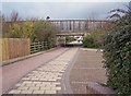
Subway under Staplehurst Road
Confusingly, there are TWO Staplehurst Roads here. It's the "new" one which runs over this subway. The road and subway were built and existing roads re-aligned to create easier access to the north side of the town.
Image: © Richard Dorrell
Taken: 21 Mar 2008
0.04 miles