IMAGES TAKEN NEAR TO
Waterloo Road, SITTINGBOURNE, ME10 2LN
Introduction
This page details the photographs taken nearby to Waterloo Road, ME10 2LN by members of the Geograph project.
The Geograph project started in 2005 with the aim of publishing, organising and preserving representative images for every square kilometre of Great Britain, Ireland and the Isle of Man.

There are currently over 7.5m images from over14,400 individuals and you can help contribute to the project by visiting https://www.geograph.org.uk
Image Map
Images are licensed for reuse under creativecommons.org/licenses/by-sa/2.0
Notes
- Clicking on the map will re-center to the selected point.
- The higher the marker number, the further away the image location is from the centre of the postcode.
Image Listing (63 Images Found)
Images are licensed for reuse under creativecommons.org/licenses/by-sa/2.0
Image
Details
Distance
2
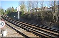
Branch line to the Isle of Sheppey
The line leaves the Chatham Main Line just west of Sittingbourne.
Image: © N Chadwick
Taken: 22 Apr 2012
0.04 miles
3
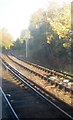
Railway to Sittingbourne
The beginning of the branch line to the Isle of Sheppey.
Image: © N Chadwick
Taken: 30 Oct 2010
0.07 miles

5
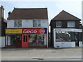
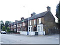
Pizza Gogo, Chalkwell Road Sittingbourne
Image: © PAUL FARMER
Taken: 16 Apr 2011
0.07 miles
9
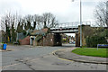
Railway bridge over Chalkwell Road
The Victoria to Ramsgate line (VIR) crosses. On this Easter Saturday there were no trains running because of engineering work. It looked like resignalling.
Image: © Robin Webster
Taken: 4 Apr 2015
0.09 miles
10
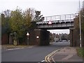
Railway bridge over Chalkwell Road
Railway travels from London/Medway (on left) towards Sittingbourne/Dover (on right). Also has footpath tunnel under railway towards Milton Regis Town.
Image: © David Anstiss
Taken: 5 Nov 2008
0.09 miles