IMAGES TAKEN NEAR TO
Redgrove Avenue, SITTINGBOURNE, ME10 2FQ
Introduction
This page details the photographs taken nearby to Redgrove Avenue, ME10 2FQ by members of the Geograph project.
The Geograph project started in 2005 with the aim of publishing, organising and preserving representative images for every square kilometre of Great Britain, Ireland and the Isle of Man.

There are currently over 7.5m images from over14,400 individuals and you can help contribute to the project by visiting https://www.geograph.org.uk
Image Map
Images are licensed for reuse under creativecommons.org/licenses/by-sa/2.0
Notes
- Clicking on the map will re-center to the selected point.
- The higher the marker number, the further away the image location is from the centre of the postcode.
Image Listing (200 Images Found)
Images are licensed for reuse under creativecommons.org/licenses/by-sa/2.0
Image
Details
Distance
1
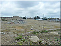
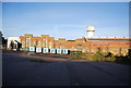
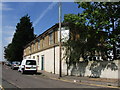
Demolition site, Sittingbourne
Formerly Bowaters paper mill.
Image: © Robin Webster
Taken: 4 Apr 2015
0.03 miles
2
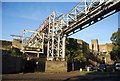
Pipeline into Sittingbourne Mill
A, now closed, paper mill.
Image: © N Chadwick
Taken: 30 Oct 2010
0.03 miles
3
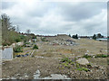
Demolition site, Sittingbourne
Formerly Bowaters paper mill.
Image: © Robin Webster
Taken: 4 Apr 2015
0.03 miles
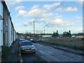
4
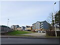
Houses on Redgrove Avenue
As seen from B2006 Mill Way.
Image: © David Anstiss
Taken: 28 Jan 2022
0.04 miles
5
Sittingbourne Mill
A, now closed and soon to be demolished, paper mill.
Image: © N Chadwick
Taken: 30 Oct 2010
0.05 miles
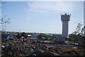
7
Tower on the site of Sittingbourne Paper Mill
Image: © N Chadwick
Taken: 22 Apr 2012
0.05 miles
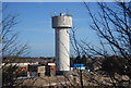
10
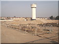
Sittingbourne Mill Water Tower
The only remaining part of Image
The rest of the building was demolished last year.
Image: © David Anstiss
Taken: 22 Mar 2012
0.06 miles