IMAGES TAKEN NEAR TO
Swale Way, SITTINGBOURNE, ME10 2FF
Introduction
This page details the photographs taken nearby to Swale Way, ME10 2FF by members of the Geograph project.
The Geograph project started in 2005 with the aim of publishing, organising and preserving representative images for every square kilometre of Great Britain, Ireland and the Isle of Man.

There are currently over 7.5m images from over14,400 individuals and you can help contribute to the project by visiting https://www.geograph.org.uk
Image Map
Images are licensed for reuse under creativecommons.org/licenses/by-sa/2.0
Notes
- Clicking on the map will re-center to the selected point.
- The higher the marker number, the further away the image location is from the centre of the postcode.
Image Listing (13 Images Found)
Images are licensed for reuse under creativecommons.org/licenses/by-sa/2.0
Image
Details
Distance
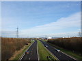
1
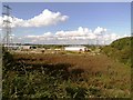
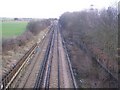
Railway towards the A249 Sheppey Bridge
Seen from Image This line leads from Sittingbourne to Sheerness.
The A249 is a road bridge, while the railway takes the flatter old bridge over the Swale Strait.
Image: © David Anstiss
Taken: 16 Feb 2010
0.06 miles
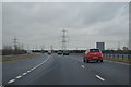
4
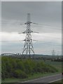
Pylons near Kemsley
Looking across the A249 towards the two Sheppey crossings. The pylon in the foreground is reference number TP118 -- the line is operated by the National Grid and carries power from Littlebrook power station to Kemsley substation.
Image: © Danny P Robinson
Taken: 17 May 2013
0.15 miles
5
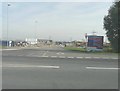
New Logistics Hub, Swale Way (B2005)
The information board, seen to the right of the entrance, announces that the site “opens summer 2014” and that it is a “state of the art haulage site developed for Nicholls Transport” http://www.nicholls.eu
Image: © John Baker
Taken: 28 Sep 2014
0.16 miles
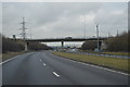
6
Heading for the bridge
The railway (on the right) converges with the A249 Sheppey Way (on the left) as both head for the Kingsferry Bridge onto the Isle of Sheppey. All piers for the new bridge are now complete.
Image: © Penny Mayes
Taken: 21 May 2005
0.17 miles
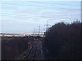
7
Railway to Sheerness
As seen from Image This line leads from Sittingbourne (via Kemsley) towards the Isle of Sheppey with Queenborough and Sheerness stations.
On the left is the Iwade Marshes.
Image: © David Anstiss
Taken: 16 Feb 2010
0.18 miles
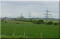
8
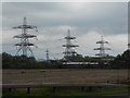
Terminal Pylons at Kemsley Substation
Kemsley is a major electricity substation. All the overhead powerlines in the vicinity link to this place. In the background, the blue building is a Morrisons distribution depot. In the foreground is a train going between Sittingbourne and Sheerness.
Image: © Danny P Robinson
Taken: 17 May 2013
0.19 miles