IMAGES TAKEN NEAR TO
Fleet End, SITTINGBOURNE, ME10 2FD
Introduction
This page details the photographs taken nearby to Fleet End, ME10 2FD by members of the Geograph project.
The Geograph project started in 2005 with the aim of publishing, organising and preserving representative images for every square kilometre of Great Britain, Ireland and the Isle of Man.

There are currently over 7.5m images from over14,400 individuals and you can help contribute to the project by visiting https://www.geograph.org.uk
Image Map
Images are licensed for reuse under creativecommons.org/licenses/by-sa/2.0
Notes
- Clicking on the map will re-center to the selected point.
- The higher the marker number, the further away the image location is from the centre of the postcode.
Image Listing (10 Images Found)
Images are licensed for reuse under creativecommons.org/licenses/by-sa/2.0
Image
Details
Distance
2
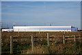
Morrison's Distribution Centre, second warehouse
Image: © N Chadwick
Taken: 30 Oct 2010
0.07 miles
3
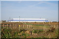
Blue Giant
This is a new distribution centre being built for Morrisons supermarket.
Image: © Phil Bull
Taken: 1 May 2009
0.13 miles
4
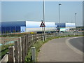
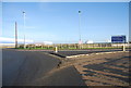
Roundabout, Barge Way
The large warehiouses in the background are Morrison's distribution centre.
Image: © N Chadwick
Taken: 30 Oct 2010
0.15 miles
5
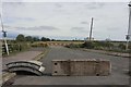
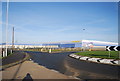
Future road off Barge Way and Fleet End roundabout
Image: © Oast House Archive
Taken: 18 Jul 2020
0.15 miles
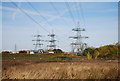
9
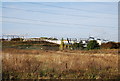
Electrical sub-station, Coldharbour Marshes
Image: © N Chadwick
Taken: 30 Oct 2010
0.24 miles
10
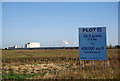
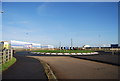
Plot 2, G Park, Coldharbour Marshes
Potential development area for warehouses or such like.
Image: © N Chadwick
Taken: 30 Oct 2010
0.25 miles