IMAGES TAKEN NEAR TO
Saffron Way, SITTINGBOURNE, ME10 2EX
Introduction
This page details the photographs taken nearby to Saffron Way, ME10 2EX by members of the Geograph project.
The Geograph project started in 2005 with the aim of publishing, organising and preserving representative images for every square kilometre of Great Britain, Ireland and the Isle of Man.

There are currently over 7.5m images from over14,400 individuals and you can help contribute to the project by visiting https://www.geograph.org.uk
Image Map
Images are licensed for reuse under creativecommons.org/licenses/by-sa/2.0
Notes
- Clicking on the map will re-center to the selected point.
- The higher the marker number, the further away the image location is from the centre of the postcode.
Image Listing (75 Images Found)
Images are licensed for reuse under creativecommons.org/licenses/by-sa/2.0
Image
Details
Distance
3
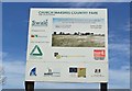
Church Marshes Country Park sign
The park is still being created - the sign reads "Reclamation of fifty hectares of former landfill site for the benefit of the local community".
Image: © Richard Dorrell
Taken: 2 Mar 2008
0.07 miles
4

Big plant
Some massive machinery is being used to crush and grade the infill which is being used to "cover up" the former landfill site here, and create Church Marshes Country Park. Work on about three quarters of the site is complete.
Image: © Richard Dorrell
Taken: 2 Mar 2008
0.07 miles
7
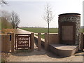
Milton Creek Country Park entrance, near Holy Trinity Church
This entrance leads from Green Porch Close, near the church into the new country park.
Image: © David Anstiss
Taken: 22 Mar 2012
0.10 miles
8
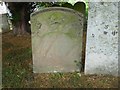
Gravestone in Holy Trinity Churchyard, Milton Regis
Large parts of the church date from the 14th century, including the tower. It also has a very large and interesting churchyard including a number of gravestones dating back to the first half of the 18th century as seen here.
The oldest part of the church is a Roman wall from the second century CE. The original church building dates to 650 CE with additions in the 11th and 14th centuries. The tower is said to be the largest in Kent and the third largest tower in England. The church is Grade I Listed.
Image: © Marathon
Taken: 27 Jun 2020
0.11 miles
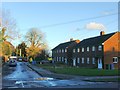
10
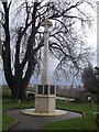
Milton Regis War Memorial
This war memorial has recently been restored and re-erected beside Holy Trinity Church.
See http://www.telegraph.co.uk/history/britain-at-war/9623577/Restored-at-last-memorial-destroyed-in-Great-Storm.html# for more about the memorial service.
Image: © David Anstiss
Taken: 25 Dec 2012
0.11 miles