IMAGES TAKEN NEAR TO
Sprotshill Close, SITTINGBOURNE, ME10 2BE
Introduction
This page details the photographs taken nearby to Sprotshill Close, ME10 2BE by members of the Geograph project.
The Geograph project started in 2005 with the aim of publishing, organising and preserving representative images for every square kilometre of Great Britain, Ireland and the Isle of Man.

There are currently over 7.5m images from over14,400 individuals and you can help contribute to the project by visiting https://www.geograph.org.uk
Image Map
Images are licensed for reuse under creativecommons.org/licenses/by-sa/2.0
Notes
- Clicking on the map will re-center to the selected point.
- The higher the marker number, the further away the image location is from the centre of the postcode.
Image Listing (33 Images Found)
Images are licensed for reuse under creativecommons.org/licenses/by-sa/2.0
Image
Details
Distance
4
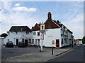
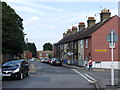
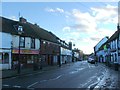
The Britannia, Milton Regis
Former pub now a kebab shop.
Image: © Chris Whippet
Taken: 8 Aug 2013
0.12 miles
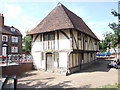
7
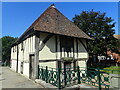
The Old Court Hall at Milton Regis
The Old Court Hall at Milton Regis was built around 1450 and repaired in 1958. The window above the door came from a demolished house in Mill Street.
Image: © Marathon
Taken: 18 Jul 2021
0.14 miles
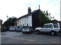
10
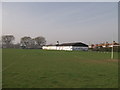
Vicarage Road Sports Centre, Milton Regis
Vicarage Road is on the right.
Image: © David Anstiss
Taken: 22 Mar 2012
0.16 miles