IMAGES TAKEN NEAR TO
Tunstall Road, SITTINGBOURNE, ME10 1YQ
Introduction
This page details the photographs taken nearby to Tunstall Road, ME10 1YQ by members of the Geograph project.
The Geograph project started in 2005 with the aim of publishing, organising and preserving representative images for every square kilometre of Great Britain, Ireland and the Isle of Man.

There are currently over 7.5m images from over14,400 individuals and you can help contribute to the project by visiting https://www.geograph.org.uk
Image Map
Images are licensed for reuse under creativecommons.org/licenses/by-sa/2.0
Notes
- Clicking on the map will re-center to the selected point.
- The higher the marker number, the further away the image location is from the centre of the postcode.
Image Listing (44 Images Found)
Images are licensed for reuse under creativecommons.org/licenses/by-sa/2.0
Image
Details
Distance
8
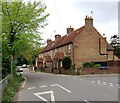
Tunstall pond from the churchyard
Curiously shaped pond beside the road in Tunstall. The brick wall is a fairly recent addition, presumably for safety reasons. I think the pond existed for tightening cart wheels. The house is Hales House, originally built for the Hales family in 1630 - Tunstall House is also associated with the family who have a tomb in the church.
My thanks to Stephen Lynas for the following extra information:
'The pond was universally known as "Coffin Pond" when I was a child (1950s/60s). It has a slope into it at the church end - giving credibility to the cartwheel theory - but was otherwise walled off from the road. There always was a brick wall (of old bricks like Hales House), and it made the pond a perfect coffin shape. But somewhere around 1968 someone (not me, but I was told who it was...) drove into the wall and it was demolished. I think in the 70s rather nasty concrete posts and wire were put up. This present wall is therefore relatively new and unfortunately the pond shape has been smoothed out so it no longer resembles a coffin. But it looks much better now than after the original wall was demolished.'
Image: © Penny Mayes
Taken: 12 May 2005
0.11 miles
9
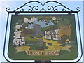
Close-up of Tunstall Village Sign
A millennium project for the village. It has replaced an earlier sign.
See also Image
Image: © David Anstiss
Taken: 27 Aug 2009
0.12 miles