IMAGES TAKEN NEAR TO
Park Avenue, SITTINGBOURNE, ME10 1QY
Introduction
This page details the photographs taken nearby to Park Avenue, ME10 1QY by members of the Geograph project.
The Geograph project started in 2005 with the aim of publishing, organising and preserving representative images for every square kilometre of Great Britain, Ireland and the Isle of Man.

There are currently over 7.5m images from over14,400 individuals and you can help contribute to the project by visiting https://www.geograph.org.uk
Image Map
Images are licensed for reuse under creativecommons.org/licenses/by-sa/2.0
Notes
- Clicking on the map will re-center to the selected point.
- The higher the marker number, the further away the image location is from the centre of the postcode.
Image Listing (16 Images Found)
Images are licensed for reuse under creativecommons.org/licenses/by-sa/2.0
Image
Details
Distance
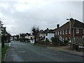
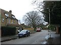
3
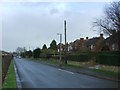
Houses on Woodstock Road, Sittingbourne
Image: © David Howard
Taken: 19 Mar 2017
0.12 miles
5
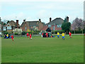
Football match, Sittingbourne
There were two matches in progress at this private sports ground.
Image: © Robin Webster
Taken: 4 Apr 2015
0.13 miles
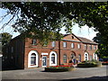
6
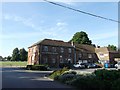
King Georges Pavilion, Sittingbourne
Large sports pavilion and nursery, near King George's Recreational Ground.
Accessed from Park Drive.
Image: © David Anstiss
Taken: 6 Sep 2012
0.13 miles
8
King Georges Pavilion, Sittingbourne
Large sports pavilion and nursery, near King George's Recreational Ground.
Image: © David Anstiss
Taken: 6 Sep 2012
0.14 miles