IMAGES TAKEN NEAR TO
Micketts Gardens, SITTINGBOURNE, ME10 1GD
Introduction
This page details the photographs taken nearby to Micketts Gardens, ME10 1GD by members of the Geograph project.
The Geograph project started in 2005 with the aim of publishing, organising and preserving representative images for every square kilometre of Great Britain, Ireland and the Isle of Man.

There are currently over 7.5m images from over14,400 individuals and you can help contribute to the project by visiting https://www.geograph.org.uk
Image Map
Images are licensed for reuse under creativecommons.org/licenses/by-sa/2.0
Notes
- Clicking on the map will re-center to the selected point.
- The higher the marker number, the further away the image location is from the centre of the postcode.
Image Listing (20 Images Found)
Images are licensed for reuse under creativecommons.org/licenses/by-sa/2.0
Image
Details
Distance
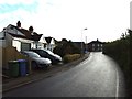
2
New Woodland
This shelter belt of trees has been planted on the southern edge of a recently built housing estate. This gives shelter to the houses from the fierce north winds, also gives a pleasant landscape to the estate. Also nice for dog owners.
Image: © David Anstiss
Taken: 12 Jan 2009
0.09 miles
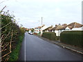
3
Westlands School
New housing development on the left, school obscured by trees in the centre. Seen from Cryalls Lane, the well used footpath across the cereal crop probably takes children from Borden village to the High school.
Image: © Penny Mayes
Taken: 17 May 2005
0.12 miles
6
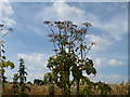
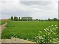
Hogweed at the edge of the wheat field in Wises Lane
Wises Lane leads from the A2 at Key Street to Borden.
Image: © pam fray
Taken: 30 Jul 2008
0.17 miles
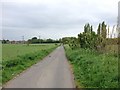
7
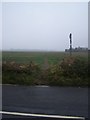
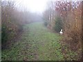
Footpath on Cryalls Lane
Path leads to Maylam Gardens, Sittingbourne.
Image: © David Anstiss
Taken: 14 Jan 2009
0.18 miles
9
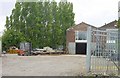
Steel fabricators on Cryalls Lane
The buildings were originally associated with hop-drying but no hops have been grown in this area for many years.
Image: © Penny Mayes
Taken: 17 May 2005
0.20 miles