IMAGES TAKEN NEAR TO
Grange Park Road, MANCHESTER, M9 7AF
Introduction
This page details the photographs taken nearby to Grange Park Road, M9 7AF by members of the Geograph project.
The Geograph project started in 2005 with the aim of publishing, organising and preserving representative images for every square kilometre of Great Britain, Ireland and the Isle of Man.

There are currently over 7.5m images from over14,400 individuals and you can help contribute to the project by visiting https://www.geograph.org.uk
Image Map
Images are licensed for reuse under creativecommons.org/licenses/by-sa/2.0
Notes
- Clicking on the map will re-center to the selected point.
- The higher the marker number, the further away the image location is from the centre of the postcode.
Image Listing (12 Images Found)
Images are licensed for reuse under creativecommons.org/licenses/by-sa/2.0
Image
Details
Distance
1
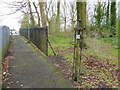
Path by the former Booth Hall estate
The path from Bailey's Wood as it nears Grange Park Road has some old cast iron fencing from the Booth Hall estate that became a children's hospital site and is now a housing estate.
Image: © Kevin Waterhouse
Taken: 27 Mar 2024
0.07 miles
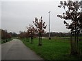
2
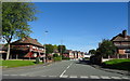
Booth Hall Road, Charlestown
Looking north from Charlestown Road.
Image: © JThomas
Taken: 25 Sep 2018
0.10 miles
3
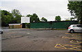
Boggart Hole Clough Visitor Centre
Perhaps it looks more appealing when it is open!
Image: © Bill Boaden
Taken: 7 Jun 2010
0.13 miles
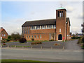
5
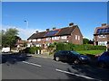
Saint John Bosco Roman Catholic Church
On Charlestown Road.
Image: © JThomas
Taken: 25 Sep 2018
0.15 miles
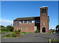
6
St John Bosco Church
St John Bosco Church on Charlestown Road, Blackley.
Image: © David Dixon
Taken: 9 Apr 2010
0.15 miles
7
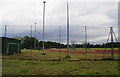
The athletics track, Boggart Hole Clough
A useful facility which is open for ordinary people to run on.
Image: © Bill Boaden
Taken: 7 Jun 2010
0.20 miles
8
Boggart Hole Clough, Manchester
Boggart Hole Clough occupies 190 acres. The word "clough" is a northern expression for a steep sided valley and the site has many by ravines and gullies within this remnant of ancient forest. In 2007 it was designated as a Local Nature Reserve. A Boggart is a mythological creature sometimes described as a "household fairy". Generally mischievous they are blamed for curdling the milk and playing tricks on people. They are thought to live under bridges, like trolls, on sharp bends in roads and, in this case, in woodland.
Image: © Tricia Neal
Taken: 3 Dec 2013
0.21 miles
9
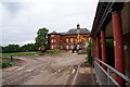
The sorry state of Booth Hall Children's Hospital
This has closed following mergers, and is replaced by a site near the University which is infinitely harder to get to and to park at. I don't know what the current plans are for this site.
Off the record, both of my children have received treatment here.
Image: © Bill Boaden
Taken: 7 Jun 2010
0.22 miles
10
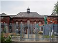
Booth Hall Children's Hospital, Blackley, Manchester
On 28th October 1908 the opening ceremony of the Prestwich Union Workhouse Infirmary was held. During the First World War it helped to care for wounded soldiers. When this was no longer required, the new Manchester Union Guardians decided to create an infirmary specifically for children. By 1924 it was a recognised training school for children’s nurses.
By 1929 it was the third largest children’s hospital in the UK. It was the home of many innovations: the first infant diet kitchen, a burns and plastic surgery unit, a children’s dialysis unit; provision of overnight accommodation for the parents of seriously ill children.
In 1990 it was proposed to close it but massive protests ensued and it remained open. However, closure did finally come a few years later, and it was sold for re-development. Buildings were demolished, except for the administration block, which everyone was told would be turned into flats. But somewhere along the way that idea was dropped and it was demolished earlier this year. Now only the gatehouse remains.
Image: © Tricia Neal
Taken: 10 Jul 2013
0.22 miles