IMAGES TAKEN NEAR TO
Tavistock Square, MANCHESTER, M9 5RD
Introduction
This page details the photographs taken nearby to Tavistock Square, M9 5RD by members of the Geograph project.
The Geograph project started in 2005 with the aim of publishing, organising and preserving representative images for every square kilometre of Great Britain, Ireland and the Isle of Man.

There are currently over 7.5m images from over14,400 individuals and you can help contribute to the project by visiting https://www.geograph.org.uk
Image Map
Images are licensed for reuse under creativecommons.org/licenses/by-sa/2.0
Notes
- Clicking on the map will re-center to the selected point.
- The higher the marker number, the further away the image location is from the centre of the postcode.
Image Listing (28 Images Found)
Images are licensed for reuse under creativecommons.org/licenses/by-sa/2.0
Image
Details
Distance
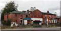
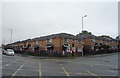
1
Harpurhey Shopper
The Harpurhey Shopper on Rochdale Road.
Image: © Peter McDermott
Taken: 25 Apr 2015
0.07 miles
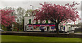
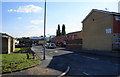
2
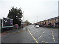
Rochdale Road
Buildings on Rochdale Road.
Image: © Peter McDermott
Taken: 17 Oct 2014
0.09 miles
3
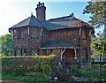
Lodge, Rochdale Road, Manchester
Now in Queen's Park, but originally serving Hendham Hall (Hendleham in Pevsner) which was demolished in 1880. Derelict at the time and there is no sign of any improvement since.
Image: © Stephen Richards
Taken: 24 May 2016
0.10 miles
4
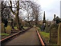
Manchester General (Harpurhey) Cemetery
Manchester General Cemetery, now commonly referred to as Harpurhey Cemetery, is situated off Rochdale Road in North Manchester, next to Queen's Park. It is made up of both Non Conformist and Consecrated ground.
The Cemetery originally opened in 1837 and at the time, was privately owned, Manchester City Council acquired the cemetery around the 1960s.
Image: © David Dixon
Taken: 5 Mar 2014
0.12 miles
5
Chevington Drive, Harpurhey
In the background can be seen the new Manchester Communication Academy, built on waste land on the corner of Rochdale Road and Queens Road.
Image: © Bill Boaden
Taken: 17 Jun 2010
0.14 miles
6
Rochdale Road
The A664 passing Queen's Park.
Image: © Gerald England
Taken: 1 Oct 2011
0.16 miles
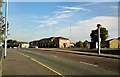
9
Rochdale Road (A664), Manchester
Looking north east.
Image: © JThomas
Taken: 17 Sep 2018
0.18 miles
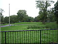
10
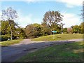
Queen's Park
The South-East corner of Queen's Park. It was one of the first parks in Manchester opened on the same day in 1846 as Phillips Park. It is part of a green corridor leading out of the city centre along the River Irk. The land originally belonged to the Houghton Family. They built Hendham Hall on the site in 1800. In 1845 the park was designed and laid out by Joshua Major and purchased by Manchester Corporation for £7,200 in 1846. https://manchesterhistory.net/manchester/squares/queenspark.html
Image: © Gerald England
Taken: 1 Oct 2011
0.19 miles