IMAGES TAKEN NEAR TO
Kendrew Walk, MANCHESTER, M9 4AJ
Introduction
This page details the photographs taken nearby to Kendrew Walk, M9 4AJ by members of the Geograph project.
The Geograph project started in 2005 with the aim of publishing, organising and preserving representative images for every square kilometre of Great Britain, Ireland and the Isle of Man.

There are currently over 7.5m images from over14,400 individuals and you can help contribute to the project by visiting https://www.geograph.org.uk
Image Map
Images are licensed for reuse under creativecommons.org/licenses/by-sa/2.0
Notes
- Clicking on the map will re-center to the selected point.
- The higher the marker number, the further away the image location is from the centre of the postcode.
Image Listing (42 Images Found)
Images are licensed for reuse under creativecommons.org/licenses/by-sa/2.0
Image
Details
Distance
2
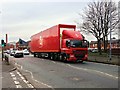
Royal Mail on Rochdale Road
Royal Mail articulated lorry (PN09 JJO) travelling north along Rochdale Road (A664).
Image: © David Dixon
Taken: 5 Mar 2014
0.06 miles
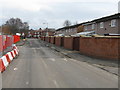
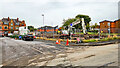
3
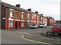
Harpurhey
The 'Parkmount Road' development in Harpurhey.
Image: © Peter McDermott
Taken: 2 Sep 2024
0.06 miles
5
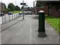
Blackley, old postbox
Penfold-type postbox bearing the number M4 336 on Rochdale Road, unusually painted green; green was apparently the original colour. http://www.wicks.org/pulp/part1.html
Image: © Mike Faherty
Taken: 29 Aug 2009
0.07 miles
7
The Alliance Inn
The Alliance Inn public house.
Image: © Peter McDermott
Taken: 17 Oct 2014
0.07 miles
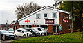
9
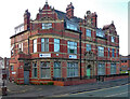
Former pub, Rochdale Road, Manchester
Big florid Victorian pub, rebuilt in 1896. It was the Farmyard Hotel, and perhaps closed in the 2010s.
At the time it housed the Harpurhey Alternative Provision School.
Image: © Stephen Richards
Taken: 24 May 2016
0.09 miles
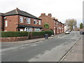
10
Harpurhey
The southern extent of the 'Parkmount Road' development in Harpurhey.
Image: © Peter McDermott
Taken: 2 Sep 2024
0.09 miles