IMAGES TAKEN NEAR TO
Humphrey Street, MANCHESTER, M8 9JS
Introduction
This page details the photographs taken nearby to Humphrey Street, M8 9JS by members of the Geograph project.
The Geograph project started in 2005 with the aim of publishing, organising and preserving representative images for every square kilometre of Great Britain, Ireland and the Isle of Man.

There are currently over 7.5m images from over14,400 individuals and you can help contribute to the project by visiting https://www.geograph.org.uk
Image Map
Images are licensed for reuse under creativecommons.org/licenses/by-sa/2.0
Notes
- Clicking on the map will re-center to the selected point.
- The higher the marker number, the further away the image location is from the centre of the postcode.
Image Listing (57 Images Found)
Images are licensed for reuse under creativecommons.org/licenses/by-sa/2.0
Image
Details
Distance
1
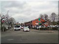
Arlington Street
On the right is the Wellfield Medical Centre. The First bus is on route #52 which is a cross-city service from Cheetham Hill to Eccles via Salford Shopping City.
Image: © Gerald England
Taken: 5 Dec 2017
0.05 miles
2
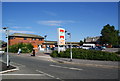
Worldwide Foodstores
Now a national Asian supermarket chain, which supplies halal meat.
Image: © Bill Boaden
Taken: 21 Jun 2010
0.06 miles
3
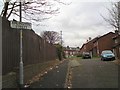
Wellfield Road
Wellfield Road used to go from Arlington Road to Dobroyd Street but now is cut off in the middle and has become a pair of cul-de-sacs.
Image: © Gerald England
Taken: 5 Dec 2017
0.08 miles
4
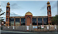
Mosque
North Manchester Jamia Mosque.
Image: © Peter McDermott
Taken: 30 Apr 2020
0.11 miles
5
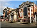
The Old Cheetham Hill District Library, Manchester
This grand old building began as the local library, closed down when new one was built nearby. It then had one or two other uses, before closing completely and falling into decay. It is sad to see a Grade II listed building with buddleias growing out of its roof. Whilst searching for information, I not only discovered it was listed, but also that there was an i-petition to save it (with a miserable 25 signatures) and a campaign on Facebook. Here are a few extracts from the description on the English Heritage listing page:
"Henry Price (the City Architect); altered. Red brick and white limestone...Edwardian Baroque style. High single storey over basement, 3 wide bays...projected wings embracing a central entrance lobby with projected porch...high stepped stone parapet...rectangular porch with channelled rustication, a round-headed doorway with voluted keystone and open-pedimented architrave with coupled columns, and semi-spherical roof...pilasters with cartouches lettered "SCOTT" and "MILTON" (left wing) "SHAKESPEARE" and "DICKENS" (right wing)...Basement area protected by wrought-iron railings with limestone piers, geometrical open-work standards, bar railings with attached swags and festoons, and flaming-urn finials."
Image: © Tricia Neal
Taken: 2 Jan 2014
0.11 miles
6
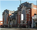
Former library, Cheetham Hill Road, Manchester
A fine Edwardian Baroque affair by Henry Price, City Architect, in 1909-11. Grade II listed.
It has now been disused for at least fifteen years. Satellite images show it to be roofless which is always a very bad sign.
Image: © Stephen Richards
Taken: 24 May 2016
0.12 miles
7
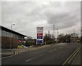
Tesco, Cheetham Hill
Exit (only) from Tesco onto Arlington Road.
Image: © Gerald England
Taken: 5 Dec 2017
0.12 miles
8
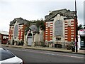
Former Crumpsall & Cheetham District Library
On Cheetham Hill Road
Image: © Kevin Waterhouse
Taken: 29 Aug 2023
0.12 miles
9
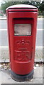
Elizabeth II postbox on Cheetham Hill Road
Postbox No. M8 647.
See Image] for context.
Image: © JThomas
Taken: 10 Sep 2018
0.12 miles
10
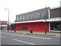
Shops on Cheetham Hill Road
Showing position of Postbox No. M8 647.
See Image] for postbox.
Image: © JThomas
Taken: 10 Sep 2018
0.12 miles