IMAGES TAKEN NEAR TO
Halliwell Lane, MANCHESTER, M8 9FR
Introduction
This page details the photographs taken nearby to Halliwell Lane, M8 9FR by members of the Geograph project.
The Geograph project started in 2005 with the aim of publishing, organising and preserving representative images for every square kilometre of Great Britain, Ireland and the Isle of Man.

There are currently over 7.5m images from over14,400 individuals and you can help contribute to the project by visiting https://www.geograph.org.uk
Image Map (Loading...)


Getting Data...Please wait
Leaflet Map data © OpenStreetMap
Images are licensed for reuse under creativecommons.org/licenses/by-sa/2.0
Notes
- Clicking on the map will re-center to the selected point.
- The higher the marker number, the further away the image location is from the centre of the postcode.
Image Listing (37 Images Found)
Images are licensed for reuse under creativecommons.org/licenses/by-sa/2.0
Image
Details
Distance
1
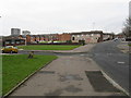
Everhurst Road Housing Estate, Cheetham Hill
A large estate of modern terraced housing. The building immediately beyond the gold car is a mosque.
Image: © Peter Whatley
Taken: 28 Feb 2009
0.06 miles
2
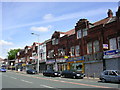
Cheetham Hill Road, Cheetham Hill, Manchester
A busy, multi-cultural area to the north of Manchester city centre. These buildings date from 1898. SD840013.
Image: © Keith Williamson
Taken: 11 May 2005
0.12 miles
3
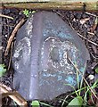
Old Boundary Marker by Marlborough Road, Salford
Parish Boundary Marker by the UC road, in parish of Salford (Salford District), Marlborough Road, immediately behind front garden wall of 109 Marlborough Road, to right of gate.
Surveyed
Milestone Society National ID: LA_BROCHE06pb
Image: © Milestone Society
Taken: Unknown
0.12 miles
4
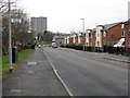
Heath Street, Cheetham Hill
At the junction with Squire Road (obviously!).
Image: © Peter Whatley
Taken: 28 Feb 2009
0.13 miles
5
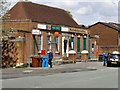
Hightown Post Office and Convenience Store
Waterloo Road, Cheetham Hill.
Image: © David Dixon
Taken: 1 May 2010
0.13 miles
6
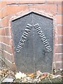
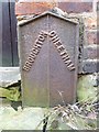
Old Boundary Marker by Orient Street, Salford parish
Parish Boundary Marker by the UC road, in parish of Salford (Salford District), Orient Street, Eastern end, against bay window wall of No 24, South side of road.
Inscription reads:-
: CHEETHAM : : BROUGHTON :
Surveyed
Milestone Society National ID: LA_BROCHE05pb
Image: © Milestone Society
Taken: Unknown
0.14 miles
7
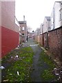
Broughton, ginnel
Between Orient and Dorothy Streets.
Image: © Mike Faherty
Taken: 26 Dec 2013
0.14 miles
8
Cheetham Hill Road, Manchester
Looking north west.
Image: © JThomas
Taken: 10 Sep 2018
0.14 miles
9
Old Boundary Marker by Orient Street, Salford
Cast Iron Parish Boundary Marker by the UC road, in parish of Salford (Salford District), behind Orient Street, in ginnel against rear wall of No 26.
Surveyed
Milestone Society National ID: LA_BROCHE09pb.
Image: © Milestone Society
Taken: Unknown
0.14 miles
10

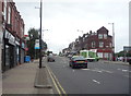
Cheetham Hill Road
The A665, looking towards the junction with Greenhill Road, Halliwell Road and Waterloo Road.
Image: © David Dixon
Taken: 1 May 2010
0.15 miles