IMAGES TAKEN NEAR TO
Elite Close, MANCHESTER, M8 9FL
Introduction
This page details the photographs taken nearby to Elite Close, M8 9FL by members of the Geograph project.
The Geograph project started in 2005 with the aim of publishing, organising and preserving representative images for every square kilometre of Great Britain, Ireland and the Isle of Man.

There are currently over 7.5m images from over14,400 individuals and you can help contribute to the project by visiting https://www.geograph.org.uk
Image Map
Images are licensed for reuse under creativecommons.org/licenses/by-sa/2.0
Notes
- Clicking on the map will re-center to the selected point.
- The higher the marker number, the further away the image location is from the centre of the postcode.
Image Listing (44 Images Found)
Images are licensed for reuse under creativecommons.org/licenses/by-sa/2.0
Image
Details
Distance
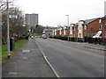
1
Cheetham Hill
Junction of St Mark's Lane and Tetlow Lane.
Image: © Peter McDermott
Taken: 28 Mar 2016
0.03 miles
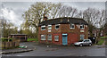
2
St. Mark's Lane, Manchester
This road leads up to the area where St. Mark's church stood before its demolition in 1998.
Image: © Tricia Neal
Taken: 2 Jan 2014
0.04 miles
3
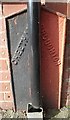
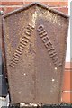
Old Boundary Marker by Japan Street, Salford Parish
Parish Boundary Marker by the UC road, in parish of Salford (Salford District), Japan Street, between front walls of Nos 7 and 9, behind downpipe.
Inscription reads:-
: CHEETHAM : : BROUGHTON :
Surveyed
Milestone Society National ID: LA_BROCHE03pb
Image: © Milestone Society
Taken: Unknown
0.04 miles
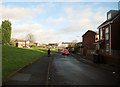
4
Heath Street, Cheetham Hill
At the junction with Squire Road (obviously!).
Image: © Peter Whatley
Taken: 28 Feb 2009
0.04 miles
5
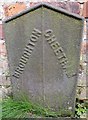
Old Boundary Marker by Japan Street, Salford Parish
Parish Boundary Marker by the UC road, in parish of Salford (Salford District), Japan Street, against front wall of No 10, East side of road.
Inscription reads:- : BROUGHTON : : CHEETHAM :
Surveyed
Milestone Society National ID: LA_BROCHE02pb
Image: © Milestone Society
Taken: Unknown
0.04 miles
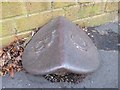
6
Old Boundary Marker in Salford Parish, in ginnel behind Japan Street
Parish Boundary Marker by the UC road, in parish of Salford (Salford District), Japan Street, ginnel behind Japan Street, against rear wall of No 1 (gate locked).
To be surveyed
Milestone Society National ID: LA_BROCHE10pb.
Image: © Milestone Society
Taken: Unknown
0.05 miles
7
Old Boundary Marker by Tetlow Lane, Salford Parish
Parish Boundary Marker by the UC road, in parish of Salford (Salford District), Tetlow Lane, opposite Great Cheetham Street East in front of college/church in pavement.
Surveyed
Milestone Society National ID: LA_BROCHE04pb
Image: © Milestone Society
Taken: Unknown
0.05 miles
8
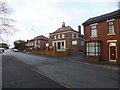
Broughton, college & church
On Tetlow Lane. The premises are shared by Bethel Community College (right) and Bethel Apostolic Ark Church (left). http://www.bethelcomcollege.co.uk/AboutUs.html
Image: © Mike Faherty
Taken: 26 Dec 2013
0.06 miles
9
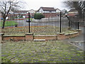
Off St. Mark's Lane, Cheetham Hill
I can't work out what this is. It lies between Copthall Lane and Grangeforth Road. The wall on the right is the boundary of the old graveyard. In the distance, the new houses are on St. Helier's Drive. It is an area of stones like cobbles, with two circular depressions which might once have been flower-beds. These railings seem to serve no purpose. I wonder if it might be the site of some historical building, but there is no plaque near by to explain it.
Image: © Tricia Neal
Taken: 20 Nov 2011
0.09 miles
10
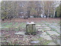
Previously St. Mark's Church and graveyard, Cheetham Hill
St. Mark's was built in 1794 and demolished in 1998.
An article pre-dating the building says: "Such was the spiritual destitution of the benighted folks of Cheetham Hill, Crumpsall, and Broughton that between the ancient parish churches of Prestwich and Manchester there was neither a place for the solemnisation of divine worship nor for the interment of the dead."
All that is there today is this sorry array of flattened gravestones, and a few memorials.
Image: © Tricia Neal
Taken: 20 Nov 2011
0.13 miles