IMAGES TAKEN NEAR TO
Copthall Lane, MANCHESTER, M8 9EP
Introduction
This page details the photographs taken nearby to Copthall Lane, M8 9EP by members of the Geograph project.
The Geograph project started in 2005 with the aim of publishing, organising and preserving representative images for every square kilometre of Great Britain, Ireland and the Isle of Man.

There are currently over 7.5m images from over14,400 individuals and you can help contribute to the project by visiting https://www.geograph.org.uk
Image Map
Images are licensed for reuse under creativecommons.org/licenses/by-sa/2.0
Notes
- Clicking on the map will re-center to the selected point.
- The higher the marker number, the further away the image location is from the centre of the postcode.
Image Listing (52 Images Found)
Images are licensed for reuse under creativecommons.org/licenses/by-sa/2.0
Image
Details
Distance
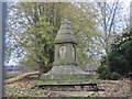
1
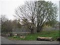
Previously St. Mark's Church, Cheetham Hill
St. Mark's was built in 1794 and demolished in 1998. When submitting these pictures I found the outline of the church still shows on the Geograph map, which was useful as I hadn't known for sure exactly where the church stood.
An article pre-dating the building says: "Such was the spiritual destitution of the benighted folks of Cheetham Hill, Crumpsall, and Broughton that between the ancient parish churches of Prestwich and Manchester there was neither a place for the solemnisation of divine worship nor for the interment of the dead."
All that is left now is a lot of litter, flattened gravestones and a few battered memorials. This view is taken approaching the area along Copthall Lane, off Cheetham Hill Road.
Image: © Tricia Neal
Taken: 20 Nov 2011
0.02 miles
2
Previously St. Mark's Church and graveyard, Cheetham Hill
St. Mark's was built in 1794 and demolished in 1998.
An article pre-dating the building says: "Such was the spiritual destitution of the benighted folks of Cheetham Hill, Crumpsall, and Broughton that between the ancient parish churches of Prestwich and Manchester there was neither a place for the solemnisation of divine worship nor for the interment of the dead."
All that is there today is this sorry array of flattened gravestones, and a few memorials.
Image: © Tricia Neal
Taken: 20 Nov 2011
0.03 miles
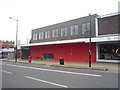
3
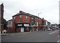
Businesses on Cheetham Hill Road, Manchester
Image: © JThomas
Taken: 10 Sep 2018
0.03 miles
4
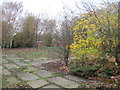
Previously St. Mark's church and graveyard, Cheetham Hill
St. Mark's was built in 1794 and demolished in 1998.
An article pre-dating the building says: "Such was the spiritual destitution of the benighted folks of Cheetham Hill, Crumpsall, and Broughton that between the ancient parish churches of Prestwich and Manchester there was neither a place for the solemnisation of divine worship nor for the interment of the dead."
The graveyard is now derelict, the railings shabby, the gates padlocked.
Image: © Tricia Neal
Taken: 20 Nov 2011
0.04 miles
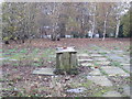
5
Previously St. Mark's Church and graveyard, Cheetham Hill
St. Mark's was built in 1794 and demolished in 1998.
An article pre-dating the building says: "Such was the spiritual destitution of the benighted folks of Cheetham Hill, Crumpsall, and Broughton that between the ancient parish churches of Prestwich and Manchester there was neither a place for the solemnisation of divine worship nor for the interment of the dead."
Today all that is left is a derelict churchyard with a few monuments.
Image: © Tricia Neal
Taken: 20 Nov 2011
0.04 miles
6
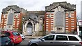
Crumpsall and Cheetham Hill Library
The Grade II listed building https://historicengland.org.uk/listing/the-list/list-entry/1197785?section=official-list-entry on Cheetham Hill Road is in a sorry state of repair. It dates from 1909-11 and is by the City Architect Henry Price. The building itself is constructed of red brick and white limestone with dressings of the same in an Edwardian Baroque style. It also comprises three wide symmetrical bays embracing a central entrance lobby with projected porch. The roof is partly glazed with the main feature being a byzantine dome.
The Library stock was moved in July 1974 to new accommodation in the Abraham Moss Centre. After serving as the Manchester Black Resource Centre, the building has been empty and unused since 2008. https://manchestervictorianarchitects.org.uk/buildings/crumpsall-district-library-cheetham-hill-road-cheetham-hill
It was sold at auction in 2015 for more than half a million pounds https://www.manchestereveningnews.co.uk/business/crumpsall-cheetham-hill-library-sold-8873858 but little seems to have happened to it since then.
Image: © Gerald England
Taken: 4 Mar 2022
0.04 miles
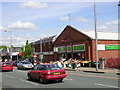
8
Shops on Cheetham Hill Road
Showing position of Postbox No. M8 647.
See Image] for postbox.
Image: © JThomas
Taken: 10 Sep 2018
0.05 miles
9
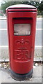
Elizabeth II postbox on Cheetham Hill Road
Postbox No. M8 647.
See Image] for context.
Image: © JThomas
Taken: 10 Sep 2018
0.05 miles
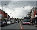
10
Cheetham Hill Road, Cheetham Hill, Manchester
An old area of Manchester, now home to a real mix of cultures.
Image: © Keith Williamson
Taken: 11 May 2005
0.05 miles