IMAGES TAKEN NEAR TO
Rygate Walk, MANCHESTER, M8 9DF
Introduction
This page details the photographs taken nearby to Rygate Walk, M8 9DF by members of the Geograph project.
The Geograph project started in 2005 with the aim of publishing, organising and preserving representative images for every square kilometre of Great Britain, Ireland and the Isle of Man.

There are currently over 7.5m images from over14,400 individuals and you can help contribute to the project by visiting https://www.geograph.org.uk
Image Map (16 Images)

Leaflet Map data © OpenStreetMap
Images are licensed for reuse under creativecommons.org/licenses/by-sa/2.0
Notes
- Clicking on the map will re-center to the selected point.
- The higher the marker number, the further away the image location is from the centre of the postcode.
Image Listing (16 Images Found)
Images are licensed for reuse under creativecommons.org/licenses/by-sa/2.0
Image
Details
Distance
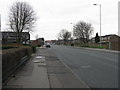
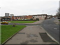
2
Brentfield Avenue, Cheetham Hill
Typical local replacements for Victorian terraced housing. Photographed from Waterloo Road.
Image: © Peter Whatley
Taken: 28 Feb 2009
0.07 miles
3
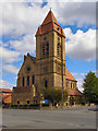
St John's Church
At the corner of Bellot Street and Waterloo Road.
Image: © David Dixon
Taken: 1 May 2010
0.09 miles
4
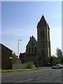
St John's, Cheetham Hill
Situated on the corner of Waterloo Road and Bellot St.
Image: © Keith Williamson
Taken: 22 Apr 2005
0.13 miles
5
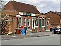
Hightown Post Office and Convenience Store
Waterloo Road, Cheetham Hill.
Image: © David Dixon
Taken: 1 May 2010
0.16 miles
6
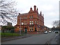
Broughton, Duke of York
A Victorian gem on Marlborough Road. Internally, front servery serving various drinking areas: games room, function room (with lovely stained glass door calling it "Billiards") pool room and bar. Etched glass front windows, some wooden servery features, tiled dado. Cask ale on offer at my visit: Holt's Bitter.
Image: © Mike Faherty
Taken: 26 Dec 2013
0.18 miles
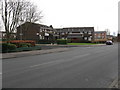
7
Everhurst Road Housing Estate, Cheetham Hill
A large estate of modern terraced housing. The building immediately beyond the gold car is a mosque.
Image: © Peter Whatley
Taken: 28 Feb 2009
0.20 miles
8
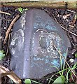
Old Boundary Marker by Marlborough Road, Salford
Parish Boundary Marker by the UC road, in parish of Salford (Salford District), Marlborough Road, immediately behind front garden wall of 109 Marlborough Road, to right of gate.
Surveyed
Milestone Society National ID: LA_BROCHE06pb
Image: © Milestone Society
Taken: Unknown
0.20 miles
9
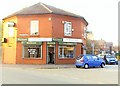
Anderton's Fish & Chip Shop - Higher Broughton
Image: © Anthony Parkes
Taken: 28 Mar 2011
0.20 miles
10
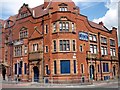
Disused hotel, Waterloo Road, Manchester
Image: © Graham Hogg
Taken: 5 Jul 2010
0.20 miles