IMAGES TAKEN NEAR TO
Nasmyth Street, MANCHESTER, M8 0RG
Introduction
This page details the photographs taken nearby to Nasmyth Street, M8 0RG by members of the Geograph project.
The Geograph project started in 2005 with the aim of publishing, organising and preserving representative images for every square kilometre of Great Britain, Ireland and the Isle of Man.

There are currently over 7.5m images from over14,400 individuals and you can help contribute to the project by visiting https://www.geograph.org.uk
Image Map (Loading...)


Getting Data...Please wait
Leaflet Map data © OpenStreetMap
Images are licensed for reuse under creativecommons.org/licenses/by-sa/2.0
Notes
- Clicking on the map will re-center to the selected point.
- The higher the marker number, the further away the image location is from the centre of the postcode.
Image Listing (136 Images Found)
Images are licensed for reuse under creativecommons.org/licenses/by-sa/2.0
Image
Details
Distance
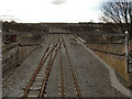
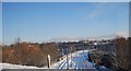
1
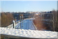
Smedley Viaduct and Metrolink control centre
A view from the bridge just after Queens Road tunnel looking toward Manchester along the former 4-track Lancashire and Yorkshire Railway 'Manchester loop'. After exiting the tunnel, the line almost immediately crossed Smedley Viaduct, with a connecting, curved viaduct up to the Manchester-Bury line. That line is now closed too, replaced by a Metrolink tram line. Metrolink's maintenance site and control centre is the blue-walled building top right. The tower slightly left of centre in the distance is the watchtower for Strangeways prison.
Image: © Peter Whatley
Taken: 9 Apr 2008
0.01 miles
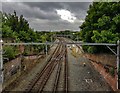
2
Smedley Viaduct
A view along the Smedley Viaduct from Collyhurst Road. The 19th century, former railway viaduct has been refurbished in readiness for the opening of the Manchester to Oldham phase of the Metrolink extension. This section, running along the abandoned railway corridor to Central Park in East Manchester was originally planned to open in spring 2011 (http://www.metrolink.co.uk/pdf/future_metrolink/latest_news_publicatios/10-0004_Link3Reprintlowres.pdf ) but that has now been revised to 2012 (http://www.metrolink.co.uk/futuremetrolink/oldham-and-rochdale-line.asp )
Image: © David Dixon
Taken: 19 Mar 2012
0.02 miles
3
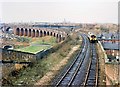
Smedley Viaduct 1989
A Manchester Victoria - Leeds train crosses the River Irk on Smedley Viaduct. In the background the Bury railway line crosses and a further viaduct, disused since the 1960s, links the two. Compare this scene with my photograph from the same spot in 2008.
Image: © Peter Whatley
Taken: 11 Feb 1989
0.02 miles
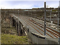
4
Metrolink Extension, Smedley Viaduct
Looking along the newly refurbished Smedley Viaduct from the road bridge at Collyhurst Road.
It was originally planned for this section of the Metrolink extension, running along the abandoned railway corridor to Central Park in East Manchester,to open in spring 2011 (http://www.metrolink.co.uk/pdf/future_metrolink/latest_news_publicatios/10-0004_Link3Reprintlowres.pdf ) but that has now been revised to 2012 (http://www.metrolink.co.uk/futuremetrolink/oldham-and-rochdale-line.asp )
Image] shows a similar view taken when trains still ran across the viaduct.
Image: © David Dixon
Taken: 19 Mar 2012
0.03 miles
5
Smedley Viaduct
The Metrolink crossing Smedley Viaduct seen from the road bridge at Collyhurst Road. Photographs of the same view in earlier years by Peter Whatley:
In 1989: Image
In 2008: Image
Image: © Peter McDermott
Taken: 15 Jul 2020
0.03 miles
6
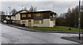
Smedley Road
Boarded up building on Smedley Road.
Image: © Peter McDermott
Taken: 28 Mar 2016
0.03 miles
7
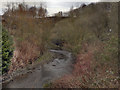
River Irk, Collyhurst
View from the bridge at Smedley Lane.
Image: © David Dixon
Taken: 19 Mar 2012
0.05 miles
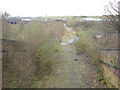
8
Old railway, Collyhurst
Now used as sidings and shunt line for the Metrolink.
Image: © N Chadwick
Taken: 19 Dec 2010
0.06 miles
9

Smedley Viaduct
A view towards Manchester, from Collyhurst Road.
Image: © David Dixon
Taken: 19 Mar 2012
0.06 miles