IMAGES TAKEN NEAR TO
Glenmore Drive, MANCHESTER, M8 0QG
Introduction
This page details the photographs taken nearby to Glenmore Drive, M8 0QG by members of the Geograph project.
The Geograph project started in 2005 with the aim of publishing, organising and preserving representative images for every square kilometre of Great Britain, Ireland and the Isle of Man.

There are currently over 7.5m images from over14,400 individuals and you can help contribute to the project by visiting https://www.geograph.org.uk
Image Map
Images are licensed for reuse under creativecommons.org/licenses/by-sa/2.0
Notes
- Clicking on the map will re-center to the selected point.
- The higher the marker number, the further away the image location is from the centre of the postcode.
Image Listing (45 Images Found)
Images are licensed for reuse under creativecommons.org/licenses/by-sa/2.0
Image
Details
Distance
1
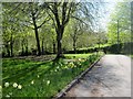
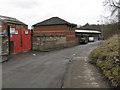
Allotments off Hazelbottom Road, Crumpsall, Manchester
A beautiful spring day, looking down the pathway which leads to the gates and the road outside.
Image: © Tricia Neal
Taken: 6 May 2013
0.04 miles
2
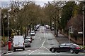
Woodlands Road
Woodlands Road in Cheetham Hill.
Image: © Peter McDermott
Taken: 28 Mar 2016
0.09 miles
3
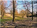
Cheetham Hill Woods
Wooded area between Woodlands Road and Hazelbottom Road.
Image: © Gerald England
Taken: 4 Mar 2010
0.09 miles
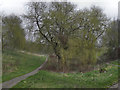
4
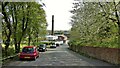
Cycle route descending to the River Irk
A view of Smedley Lane which gives a crossing of the river and allows cyclists to reach Queen's Park
Image: © Kevin Waterhouse
Taken: 26 Apr 2023
0.11 miles
5
Smedley Lane, Smedley, Manchester
A survivor of the heavy industry filled the Irk's valley locally until the 1960s.
Image: © Peter Whatley
Taken: 28 Feb 2009
0.13 miles
6
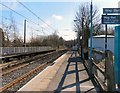
Woodlands Road Station
Metrolink tram station at Woodlands Road looking towards Manchester.
Image: © Gerald England
Taken: 4 Mar 2010
0.14 miles
7
Land Behind Woodlands Road
The open land behind Woodlands Road, below the Abraham Moss Centre.
Image: © David Dixon
Taken: 15 Mar 2012
0.15 miles
8

Footpath off Woodlands Road
Behind the trees on the left is Abraham Moss College. On the right is an area of allotments.
Image: © Gerald England
Taken: 4 Mar 2010
0.15 miles
9
Woodlands Road Station
Metrolink tram station at Woodlands Road looking towards Bury.
Image: © Gerald England
Taken: 4 Mar 2010
0.15 miles
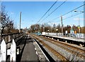
10
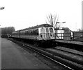
Woodlands Road station
A Class 504 unit on an Up working calls at Woodlands Road, in the days before Metrolink. The unit, unlike most others working on the line, looks quite smart in its orange and brown Manchester livery.
Image: © Dr Neil Clifton
Taken: 9 Apr 1990
0.15 miles