IMAGES TAKEN NEAR TO
Bury New Road, SALFORD, M7 4WN
Introduction
This page details the photographs taken nearby to Bury New Road, M7 4WN by members of the Geograph project.
The Geograph project started in 2005 with the aim of publishing, organising and preserving representative images for every square kilometre of Great Britain, Ireland and the Isle of Man.

There are currently over 7.5m images from over14,400 individuals and you can help contribute to the project by visiting https://www.geograph.org.uk
Image Map
Images are licensed for reuse under creativecommons.org/licenses/by-sa/2.0
Notes
- Clicking on the map will re-center to the selected point.
- The higher the marker number, the further away the image location is from the centre of the postcode.
Image Listing (50 Images Found)
Images are licensed for reuse under creativecommons.org/licenses/by-sa/2.0
Image
Details
Distance
1
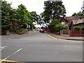
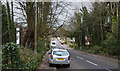
Bury New Road
The A56 towards Prestwich. The bus ahead is an X43 Witchway service to Skipton.
Image: © Gerald England
Taken: 5 Aug 2017
0.06 miles
2
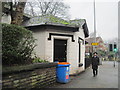
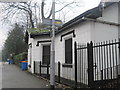
Kersal Bar Toll House, Bury New Road, Salford
Looking towards Prestwich, the door used to lead into a newsagent's shop, but the building has been empty for many years. A two-storey extension is just visible at the rear behind the tree trunk.
Image: © Tricia Neal
Taken: 24 Feb 2014
0.08 miles
3
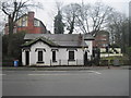
Kersal Bar Toll House, Kersal, Salford
This view was taken from the opposite side of Bury New Road. The two-storey addition along the back must have been added after the building was listed, as the description there says: "Former toll house, latterly in use as shop, but now disused. Early C19. Stucco over brick with slate roof felted over, and stack on right hand side. Single-storey, octagonal single-unit plan with additional rectangular bay to right. Entrance to left, windows in gable facing street and to right, both replaced but with original drop-ended hoodmoulds over. Probably the only surviving toll house in the Manchester and Salford area."
Image: © Tricia Neal
Taken: 19 Feb 2014
0.09 miles
4
Kersal Bar Toll House, Bury New Road, Salford
On the corner of Moor Lane and Bury Old Road, Kersal, Salford. When I was a student in a nearby hostel, this was a paper shop selling a few food items. Rather than do the 15 minute walk into college for our weekend evening meal, we often bought scones or sausage rolls here to eat in our rooms. It closed some years ago and now stands empty.
A few years ago I discovered it used to be a toll house known as Kersal Bar. When Bury New Road was built in 1831 a gate or bar was erected and travellers had to pay a toll to the turnpike trust to pass through. The toll house had bay window projecting out so that the toll collector had a clear view of the road. By 1848 the local authority had taken over the road and the tolls were abolished. The exterior of the house remains largely unchanged to this day, although it was renovated in 2007 with a two-storey extension being added to the rear. The Toll House is now a Grade II listed building.
Image: © Tricia Neal
Taken: 19 Feb 2014
0.09 miles
5
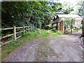
Church Lane
Track leading past St Paul's church.
Image: © Gerald England
Taken: 5 Aug 2017
0.10 miles
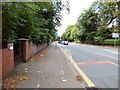
7
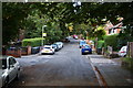
St Paul's Road, Kersal
A quiet residential road which leads to a minor access to St Paul's Church. This is looking away from the church.
Image: © Bill Boaden
Taken: 4 Sep 2012
0.11 miles
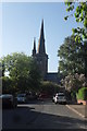
9
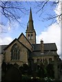
St Paul's Church, Kersal, Salford.
This church, consecrated in 1852, stands at the highest point above sea level in Salford.
Image: © Keith Williamson
Taken: 12 Apr 2005
0.12 miles