IMAGES TAKEN NEAR TO
Bingley Walk, SALFORD, M7 3QT
Introduction
This page details the photographs taken nearby to Bingley Walk, M7 3QT by members of the Geograph project.
The Geograph project started in 2005 with the aim of publishing, organising and preserving representative images for every square kilometre of Great Britain, Ireland and the Isle of Man.

There are currently over 7.5m images from over14,400 individuals and you can help contribute to the project by visiting https://www.geograph.org.uk
Image Map
Images are licensed for reuse under creativecommons.org/licenses/by-sa/2.0
Notes
- Clicking on the map will re-center to the selected point.
- The higher the marker number, the further away the image location is from the centre of the postcode.
Image Listing (30 Images Found)
Images are licensed for reuse under creativecommons.org/licenses/by-sa/2.0
Image
Details
Distance
1
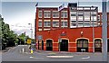
PZ Cusson
Cussons Soap Factory on the junction of Kersal Vale Road, Moor Lane and Littleton Road. This building has just recently been demolished, 2010.
Image: © Edward Smith
Taken: 22 Jun 2007
0.08 miles
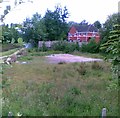
2
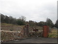
Little remains of the soap factory
PZ Cussons soap factory used to be here
Image: © John Slater
Taken: 14 Mar 2015
0.10 miles
3
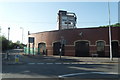
The Demolition of Cussons Soap Factory
Image: © Anthony Parkes
Taken: 24 May 2010
0.11 miles
4
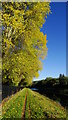
Path & autumn colours beside Agecroft Cemetery, Pendlebury
Image: © Colin Park
Taken: 18 Oct 2018
0.11 miles
5
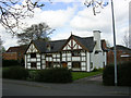
Kersal Cell, Salford
Formerly a monastic house, Kersal Cell passed into the hands of the Byrom family in the 1660s. It is believed that poet and hymn-writer John Byrom wrote and performed "Christians, Awake" here in 1749. The house is reputed to be haunted.
Image: © Keith Williamson
Taken: 29 Apr 2005
0.11 miles
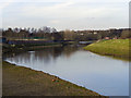
7
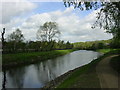
River Irwell, Salford
Looking upstream.
Image: © Keith Williamson
Taken: 29 Apr 2005
0.13 miles
9
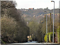
Kersal, Moor Lane
Looking down the hill at Moor Lane, towards Kersal Vale. On the other side of the valley, are signs of the newish building development near to the site of the former Agecroft Colliery.
Image: © David Dixon
Taken: 24 Feb 2011
0.15 miles
10
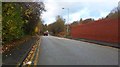
Kersal Vale Road, Prestwich
Just inside the Metropolitan Borough of Bury. The road heads in the direction of Drinkwater Park.
Image: © Bradley Michael
Taken: 18 Nov 2015
0.17 miles