IMAGES TAKEN NEAR TO
Moor Lane, SALFORD, M7 3QE
Introduction
This page details the photographs taken nearby to Moor Lane, M7 3QE by members of the Geograph project.
The Geograph project started in 2005 with the aim of publishing, organising and preserving representative images for every square kilometre of Great Britain, Ireland and the Isle of Man.

There are currently over 7.5m images from over14,400 individuals and you can help contribute to the project by visiting https://www.geograph.org.uk
Image Map
Images are licensed for reuse under creativecommons.org/licenses/by-sa/2.0
Notes
- Clicking on the map will re-center to the selected point.
- The higher the marker number, the further away the image location is from the centre of the postcode.
Image Listing (25 Images Found)
Images are licensed for reuse under creativecommons.org/licenses/by-sa/2.0
Image
Details
Distance
1
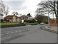
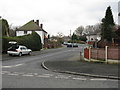
Kersal - Houses on Moor Lane
Taken from the entrance to Kersal Road.
Image: © Peter Whatley
Taken: 28 Feb 2009
0.05 miles
2
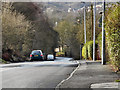
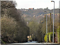
Moor Lane, Kersal
Looking down the hill at Moor Lane, towards Kersal Vale.
Image: © David Dixon
Taken: 24 Feb 2011
0.08 miles
5
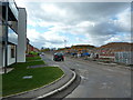
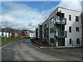
Kersal, Moor Lane
Looking down the hill at Moor Lane, towards Kersal Vale. On the other side of the valley, are signs of the newish building development near to the site of the former Agecroft Colliery.
Image: © David Dixon
Taken: 24 Feb 2011
0.14 miles
6
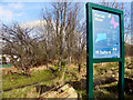
Kersal Moor
The entrance to Kersal Moor, at the corner of Moor Lane and Heathland Road.
Image: © David Dixon
Taken: 24 Feb 2011
0.14 miles
8
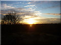
Top of Kersal Moor
The top of Kersal Moor, from where this was taken, commands views of Swinton, Pendlebury and round to The Crescent and the Manchester skyline to the west and south.
Image: © Carroll Pierce
Taken: 23 Feb 2012
0.16 miles
9

Kersal Moor, Salford
During an "Open Day" on the moor, wardens were helping to plant a community orchard near the boundary. Beyond the railings is Heathland Road at the corner with Kellbrook Crescent.
Image: © Tricia Neal
Taken: 7 Oct 2012
0.18 miles
10
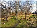
Kersal Moor
The path onto Kersal Moor from the Moor Lane entrance (Part of Moor Lane is visible on the right hand edge of the photo).
Image: © David Dixon
Taken: 24 Feb 2011
0.18 miles