IMAGES TAKEN NEAR TO
The Courtyard, SALFORD, M7 3NP
Introduction
This page details the photographs taken nearby to The Courtyard, M7 3NP by members of the Geograph project.
The Geograph project started in 2005 with the aim of publishing, organising and preserving representative images for every square kilometre of Great Britain, Ireland and the Isle of Man.

There are currently over 7.5m images from over14,400 individuals and you can help contribute to the project by visiting https://www.geograph.org.uk
Image Map (Loading...)


Getting Data...Please wait
Leaflet Map data © OpenStreetMap
Images are licensed for reuse under creativecommons.org/licenses/by-sa/2.0
Notes
- Clicking on the map will re-center to the selected point.
- The higher the marker number, the further away the image location is from the centre of the postcode.
Image Listing (52 Images Found)
Images are licensed for reuse under creativecommons.org/licenses/by-sa/2.0
Image
Details
Distance
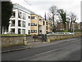
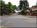
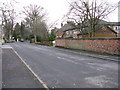
2
Kersal - Nevile Road
The new flats in the distance have their bases considerably lower down on Vine Street.
Image: © Peter Whatley
Taken: 28 Feb 2009
0.08 miles
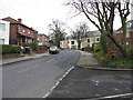
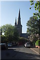
5
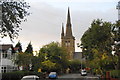
St Paul's Church, Kersal
Taken from Moorside Road because the spire is too tall to capture from close quarters.
Image: © Bill Boaden
Taken: 4 Sep 2012
0.11 miles
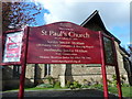
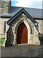
9
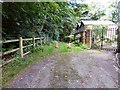
Church Lane
Track leading past St Paul's church.
Image: © Gerald England
Taken: 5 Aug 2017
0.11 miles