IMAGES TAKEN NEAR TO
Parsonage, MANCHESTER, M60 9BT
Introduction
This page details the photographs taken nearby to Parsonage, M60 9BT by members of the Geograph project.
The Geograph project started in 2005 with the aim of publishing, organising and preserving representative images for every square kilometre of Great Britain, Ireland and the Isle of Man.

There are currently over 7.5m images from over14,400 individuals and you can help contribute to the project by visiting https://www.geograph.org.uk
Image Map
Images are licensed for reuse under creativecommons.org/licenses/by-sa/2.0
Notes
- Clicking on the map will re-center to the selected point.
- The higher the marker number, the further away the image location is from the centre of the postcode.
Image Listing (2068 Images Found)
Images are licensed for reuse under creativecommons.org/licenses/by-sa/2.0
Image
Details
Distance
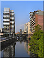
1
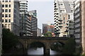
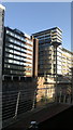
The Irwell canyon
The River Irwell looking downstream from Victoria Bridge.
Image: © Chris Denny
Taken: 17 May 2009
0.01 miles
3
Bridge Street from Spinningfields Footbridge
Bridge Street and Trinity Bridge beyond from the new footbridge at Spinningfields, Manchester. The Mark Addy, billed as "Manchester's original riverside pub", is to the left.
Image: © Carroll Pierce
Taken: 10 Aug 2012
0.02 miles
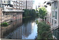
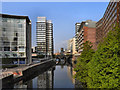
5
River Irwell from Blackfriars Bridge
The River Irwell, has always marked the invisible border between the Cities of Manchester and Salford. Here, we are looking downstream from Blackfriars Bridge past the modern apartment and office blocks now lining both banks of formerly dark and depressing area of Manchester (on the left) and Salford (on the right).
Image: © David Dixon
Taken: 4 Mar 2012
0.02 miles
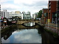
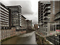
6
River Irwell, Chapel Wharf
Looking upstream from Image Ahead is Blackfriars Bridge and in the distance, Image To the left, is the newly regenerated Chapel Wharf area of Salford with its piazza and riverside walks. On right (the Manchester side of the river) the buildings are mainly 1960s office blocks backing directly on to the river although a couple have been converted into apartments complete with balconies overlooking the river.
Image: © David Dixon
Taken: 22 Apr 2011
0.02 miles
7
River Irwell, Chapel Wharf
Looking upstream from Image Ahead is Blackfriars Bridge and in the distance, Image To the left, is the newly regenerated Chapel Wharf area of Salford with its piazza and riverside walks. On right (the Manchester side of the river) the buildings are mainly 1960s office blocks backing directly on to the river although a couple have been converted into apartments complete with balconies overlooking the river.
Image: © David Dixon
Taken: 22 Apr 2011
0.02 miles
8
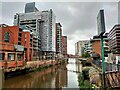
River Irwell from Blackfriars Bridge in Manchester
River scene in Manchester
Image: © Chris Heaton
Taken: 27 Aug 2023
0.02 miles
9
Back Deansgate, Manchester
The rear of various buildings (hotels, shops, apartments) that face Deansgate in Manchester city centre, from across the River Irwell in Salford, Greater Manchester.
Image: © Steven Haslington
Taken: 28 Jun 2011
0.02 miles
10
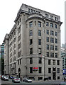
Blackfriars House, Parsonage Gardens, Manchester
Another one of those Portland stone monsters so beloved of the Edwardians and builders between the wars. The bow is an unusual touch. This one is by Harry S. Fairhurst, 1925, for the Bleachers' Association.
The Bleachers were, I believe, cleaned out at some point and this building now offers office space to anyone willing to pay the rent.
Image: © Stephen Richards
Taken: 24 Jun 2011
0.03 miles