IMAGES TAKEN NEAR TO
Middlewood Street, SALFORD, M5 4YW
Introduction
This page details the photographs taken nearby to Middlewood Street, M5 4YW by members of the Geograph project.
The Geograph project started in 2005 with the aim of publishing, organising and preserving representative images for every square kilometre of Great Britain, Ireland and the Isle of Man.

There are currently over 7.5m images from over14,400 individuals and you can help contribute to the project by visiting https://www.geograph.org.uk
Image Map (Loading...)


Getting Data...Please wait
Leaflet Map data © OpenStreetMap
Images are licensed for reuse under creativecommons.org/licenses/by-sa/2.0
Notes
- Clicking on the map will re-center to the selected point.
- The higher the marker number, the further away the image location is from the centre of the postcode.
Image Listing (261 Images Found)
Images are licensed for reuse under creativecommons.org/licenses/by-sa/2.0
Image
Details
Distance
1
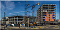
Middlewood Locks
The Middlewood Locks development in Salford.
Image: © Peter McDermott
Taken: 25 Mar 2017
0.01 miles
2
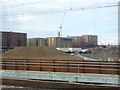
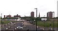
Redevelopment in progress around East Ordsall Lane
This photo was taken from a train on the new Ordsall Curve. Some new blocks of apartments are already complete or under construction, while demolition of previous buildings has been completed nearer the camera.
Image: © Stephen Craven
Taken: 24 Mar 2018
0.02 miles
3
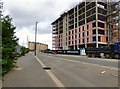
Middlewood Street
On the right is the Middlewood Locks Development http://www.middlewood-locks.co.uk/ On the left is the Fusion Apartments https://julietwist.co.uk/developments/salford-manchester/fusion-manchester/fusion/
Image: © Gerald England
Taken: 15 Jun 2017
0.03 miles
4
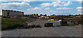
Hampson Street
Looking up Hampson Street in Salford. This is the Middlewood Locks site which is being developed by FairBriar International, a joint venture between Scarborough, Top Spring International Holdings Limited, a Hong Kong-listed real estate developer, and Metro Holdings Limited, a Singapore-listed property development and investment group.
Image: © Peter McDermott
Taken: 4 Jun 2016
0.03 miles
5
Manchester : East Orsdall Lane
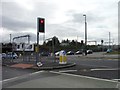
Looking towards the traffic lights at the end of East Orsdall Lane.
Image: © Lewis Clarke
Taken: 11 Oct 2014
0.04 miles
7
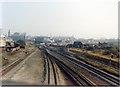
Ordsall Lane junction - new layout for Windsor Link
Ordsall Lane in 1988, after the opening of the Windsor Link route which permitted trains from south Manchester to access the Bolton and Wigan routes directly. The former Liverpool-Manchester main line is now the branch in both connections to the new route, with permanent speed restrictions of 25mph through all connections.
Image: © Peter Whatley
Taken: 15 Oct 1988
0.04 miles
8

Manchester, Bolton and Bury Canal, Lock #3
Image: © David Dixon
Taken: 11 Dec 2017
0.04 miles
9
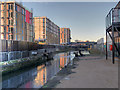
Middlewood Locks
Lock #3 on the Manchester, Bolton and Bury Canal. The buildings under construction are part of the new "Middlewood Locks" development.
Image: © David Dixon
Taken: 11 Dec 2017
0.05 miles
10
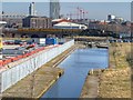
Manchester, Bolton and Bury Canal
Part of the recently restored section of canal to the west of its junction with the River Irwell. Looking towards the railway viaduct alongside the A6042. The red-brick building behind the viaduct is Image
I have been informed by John Webb that the unusual yellow-coloured train is one of Network Rail's measurement trains that tour the network examining the track at regular intervals.
Image: © David Dixon
Taken: 11 Mar 2014
0.05 miles