IMAGES TAKEN NEAR TO
Woden Street, SALFORD, M5 4YF
Introduction
This page details the photographs taken nearby to Woden Street, M5 4YF by members of the Geograph project.
The Geograph project started in 2005 with the aim of publishing, organising and preserving representative images for every square kilometre of Great Britain, Ireland and the Isle of Man.

There are currently over 7.5m images from over14,400 individuals and you can help contribute to the project by visiting https://www.geograph.org.uk
Image Map
Images are licensed for reuse under creativecommons.org/licenses/by-sa/2.0
Notes
- Clicking on the map will re-center to the selected point.
- The higher the marker number, the further away the image location is from the centre of the postcode.
Image Listing (191 Images Found)
Images are licensed for reuse under creativecommons.org/licenses/by-sa/2.0
Image
Details
Distance
3
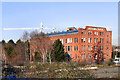
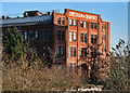
Gresham and Craven Factory
The Gresham and Craven site (former iron works?) on Ordsall Lane, Salford, viewed from the Woden Street footbridge.
Image: © David Dixon
Taken: 1 Feb 2012
0.03 miles
4
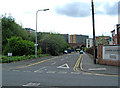
Woden Street, Salford
Woden (not Wooden) Street, is a street off Ordsall Lane, in an area of Salford which has been heavily redeveloped. On the right of the street is Lamba Court, a modern complex of multi-storey apartment blocks. The left side of the street is overgrown with vegetation, following the demolition of the buildings which were once there. No doubt it will not be long before new buildings go up here. In the distance is a viaduct which used to carry railway lines, but now takes Manchester Metrolink's trams through the centre of Manchester. The Eccles branch runs through the Salford Quays district.
Image: © P L Chadwick
Taken: 2 May 2010
0.03 miles
5
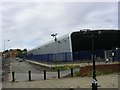
High Security!
A modern building, located in Ordsall, Salford, bristling with security measures - cameras, high fences, doubled entry gates.
Image: © Keith Williamson
Taken: 1 Sep 2005
0.04 miles
6
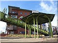
Structure by the Irwell
This hexagonal structure, by the north side of Wooden Street footbridge across the River Irwell, looks rather like a bandstand. Behind is Steele House.
Image: © Derek Harper
Taken: 19 Aug 2010
0.05 miles
7
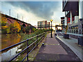
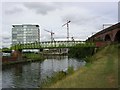
Hulme Lock, Bridgewater Canal, Manchester
This lock dropped boats from the Bridgewater Canal to the River Irwell (and to the Manchester Ship Canal). The River Medlock enters the Irwell next to the bottom gates. The railway viaducts above carry the line from Liverpool to Manchester Oxford Road, and the Metrolink trams. This lock is now disused, a new lock at Pomona connecting the Bridgewater with Salford Quays.
Image: © S Parish
Taken: Unknown
0.05 miles
8
Riverside Path at Ordsall
The footpath follows the Salford bank of the Irwell (and then the Manchester Ship Canal) allowing one to walk between (close to) the city centre and Salford Quays. The nineteenth century Woden Street footbridge can be seen ahead.
Image: © David Dixon
Taken: 2 Nov 2021
0.05 miles
10
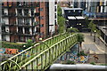
Woden Street Footbridge
This footbridge, constructed in 1873, spans the River Irwell at the end of Woden Street, Ordsall, Salford and links Salford with Manchester. Manchester is on the right bank of the river as seen here. This bridge is also known as Mark Addy's Bridge in honour of a local man, Mark Addy (1838-1890), who owned a riverside tavern and is reputed to have saved at least 50 people from drowning in the river. (http://www.manchester2002-uk.com/celebs/military.html )
Image: © Keith Williamson
Taken: 1 Sep 2005
0.07 miles