IMAGES TAKEN NEAR TO
Ordsall Lane, SALFORD, M5 4XR
Introduction
This page details the photographs taken nearby to Ordsall Lane, M5 4XR by members of the Geograph project.
The Geograph project started in 2005 with the aim of publishing, organising and preserving representative images for every square kilometre of Great Britain, Ireland and the Isle of Man.

There are currently over 7.5m images from over14,400 individuals and you can help contribute to the project by visiting https://www.geograph.org.uk
Image Map
Images are licensed for reuse under creativecommons.org/licenses/by-sa/2.0
Notes
- Clicking on the map will re-center to the selected point.
- The higher the marker number, the further away the image location is from the centre of the postcode.
Image Listing (328 Images Found)
Images are licensed for reuse under creativecommons.org/licenses/by-sa/2.0
Image
Details
Distance
1
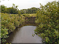
Wilburn Street Basin, River Irwell
The river basin was constructed in 1865. Its original use was for barges to conveniently collect manure, ash-pit contents and night-soil to be taken to Chat Moss to be used to fertilise the land.
Image: © David Dixon
Taken: 3 Jul 2012
0.02 miles
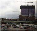
2
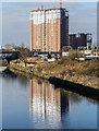
New Flats
Development of new flats in Manchester.
Image: © Peter McDermott
Taken: 20 Mar 2016
0.03 miles
3
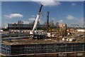
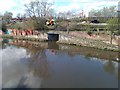
Wilburn Street Basin
Construction on the Wilburn Street Basin development site alongside the River Irwell in Salford.
Image: © Peter McDermott
Taken: 5 Apr 2015
0.03 miles
4
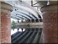
Underneath the arches
Standing under Castlefield Bridge.
Image: © R lee
Taken: 1 Jul 2006
0.03 miles
5
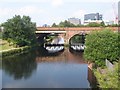
The Irwell
Railway bridge next to princess bridge that can be seen in the reflection on the river below
Image: © R lee
Taken: 1 Jul 2006
0.03 miles
6
Construction work, Ordsall Road, Salford
Image: © Mike Pennington
Taken: 12 Nov 2015
0.04 miles
7
River Irwell, Wilburn Street Basin
The river basin was constructed in 1865. Its original use was for barges to conveniently collect manure, ash-pit contents and night-soil to be taken to Chat Moss to be used to fertilise the land.
Image: © David Dixon
Taken: 3 Jul 2012
0.04 miles
8
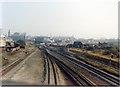
Ordsall Lane junction - new layout for Windsor Link
Ordsall Lane in 1988, after the opening of the Windsor Link route which permitted trains from south Manchester to access the Bolton and Wigan routes directly. The former Liverpool-Manchester main line is now the branch in both connections to the new route, with permanent speed restrictions of 25mph through all connections.
Image: © Peter Whatley
Taken: 15 Oct 1988
0.05 miles
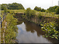
9
Bridge over entrance to disused basin beside the River Irwell
Image: © David Martin
Taken: 1 Apr 2014
0.05 miles
10

Ordsall Lane
The B5461 Ordsall Lane in Salford.
Image: © Peter McDermott
Taken: 4 Jun 2016
0.05 miles