IMAGES TAKEN NEAR TO
Ottinger Close, SALFORD, M50 3AJ
Introduction
This page details the photographs taken nearby to Ottinger Close, M50 3AJ by members of the Geograph project.
The Geograph project started in 2005 with the aim of publishing, organising and preserving representative images for every square kilometre of Great Britain, Ireland and the Isle of Man.

There are currently over 7.5m images from over14,400 individuals and you can help contribute to the project by visiting https://www.geograph.org.uk
Image Map
Images are licensed for reuse under creativecommons.org/licenses/by-sa/2.0
Notes
- Clicking on the map will re-center to the selected point.
- The higher the marker number, the further away the image location is from the centre of the postcode.
Image Listing (221 Images Found)
Images are licensed for reuse under creativecommons.org/licenses/by-sa/2.0
Image
Details
Distance
1
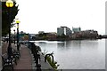
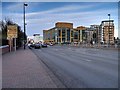
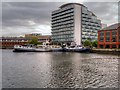
Salford Quays Buildings around South and Central Bay
Evening falls on this area of Salford Quays. The lights come on alongside Central Bay.
Image: © Tom Jolliffe
Taken: 23 Jul 2024
0.03 miles
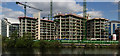
2
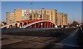
Trafford Road
New development alongside Trafford Road.
Image: © Peter McDermott
Taken: 30 Dec 2019
0.03 miles
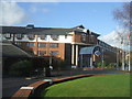
3
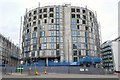
Construction site
Adjacent to Salford Docks
Image: © Anthony O'Neil
Taken: 21 Feb 2018
0.04 miles
7
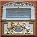
Old Trafford Bridge Plaque
Before the Manchester Ship Canal was built, the course of the River Irwell was approx. 50-100 yards further north of where the Ship Canal now passes under Trafford Road.
This plaque is next to a pedestrian tunnel under Trafford Road, roughly on the line of the old navigation. The plaque indicates the site of the Old Trafford Bridge, opened by the Mayor of Salford, Mr. Alderman F.H. Walmsley on 7th November 1878 (pre-dating the Ship Canal by sixteen years).
Image: © David Dixon
Taken: 14 May 2015
0.06 miles
8
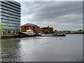
South Bay (Dock 6), Salford Quays
Salford Quays is the name given to the area of Salford which was previously the site of Manchester Docks, it became one of the first and largest urban regeneration projects in the United Kingdom following the closure of the dockyards in 1982.
This view is looking along the former Dock 6 which was between Piers 5 and 6. It is now called "South Bay".
Image: © David Dixon
Taken: 14 May 2015
0.07 miles
9
Salford Quays, South Bay (Dock 6)
Salford Quays is the name given to the area of Salford which was previously the site of Manchester Docks, it became one of the first and largest urban regeneration projects in the United Kingdom following the closure of the dockyards in 1982.
This view is looking from the path behind Merchants Quay, across the former Dock 6 which was between Piers 5 and 6. It is now called "South Bay".
Image: © David Dixon
Taken: 14 May 2015
0.07 miles
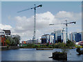
10
Clippers Quay
The Clippers Quay development alongside the Manchester Ship Canal.
Image: © Peter McDermott
Taken: 22 Apr 2017
0.07 miles