IMAGES TAKEN NEAR TO
Brightwater Close, MANCHESTER, M45 8SE
Introduction
This page details the photographs taken nearby to Brightwater Close, M45 8SE by members of the Geograph project.
The Geograph project started in 2005 with the aim of publishing, organising and preserving representative images for every square kilometre of Great Britain, Ireland and the Isle of Man.

There are currently over 7.5m images from over14,400 individuals and you can help contribute to the project by visiting https://www.geograph.org.uk
Image Map
Images are licensed for reuse under creativecommons.org/licenses/by-sa/2.0
Notes
- Clicking on the map will re-center to the selected point.
- The higher the marker number, the further away the image location is from the centre of the postcode.
Image Listing (6 Images Found)
Images are licensed for reuse under creativecommons.org/licenses/by-sa/2.0
Image
Details
Distance
1
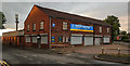
Whitefield
Industrial building on Albert Close Industrial Estate.
Image: © Peter McDermott
Taken: 11 Jun 2020
0.13 miles
2
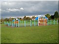
Basketball court, Oak Bank Park
Colourful apparatus in the park.
Image: © Jonathan Wilkins
Taken: 22 Oct 2016
0.18 miles
3
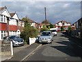
Grayson Avenue
Highly respectable and characteristic suburban housing is displayed well in Grayson Avenue.
Image: © Jonathan Wilkins
Taken: 22 Oct 2016
0.24 miles
4
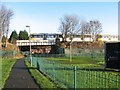
Victoria Park and Metrolink
Victoria Park forms an enclave to the east of Bury New Road. A bridge on the Metrolink line crosses a footpath route which parallels Victoria Lane.
Image: © Jonathan Wilkins
Taken: 27 Dec 2015
0.24 miles
5
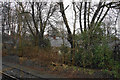
Rooftops through the trees
A view while a Metrolink tram was at a temporary standstill.
Image: © Bill Boaden
Taken: 22 Feb 2020
0.24 miles
6
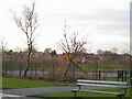
Besses o'th'Barn
Semi-detached suburbia at Whitefield, viewed across the bleak-looking playground at Oak Bank. Just east of Besses o'th'Barn station.
Image: © Roger May
Taken: 19 Dec 2005
0.25 miles