IMAGES TAKEN NEAR TO
Higher Lane, MANCHESTER, M45 7EZ
Introduction
This page details the photographs taken nearby to Higher Lane, M45 7EZ by members of the Geograph project.
The Geograph project started in 2005 with the aim of publishing, organising and preserving representative images for every square kilometre of Great Britain, Ireland and the Isle of Man.

There are currently over 7.5m images from over14,400 individuals and you can help contribute to the project by visiting https://www.geograph.org.uk
Image Map
Images are licensed for reuse under creativecommons.org/licenses/by-sa/2.0
Notes
- Clicking on the map will re-center to the selected point.
- The higher the marker number, the further away the image location is from the centre of the postcode.
Image Listing (53 Images Found)
Images are licensed for reuse under creativecommons.org/licenses/by-sa/2.0
Image
Details
Distance
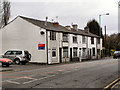
4
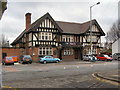
Eagle and Child
Higher Lane, Whitefield.
Image: © David Dixon
Taken: 6 Mar 2010
0.10 miles
6
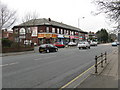
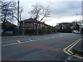
Bury New Road, Looking North
The shops mark the change of area from Besses O' Th' Barn to Whitefield.
Image: © Peter Whatley
Taken: 28 Feb 2009
0.13 miles
7
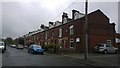
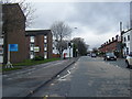
Egerton Road, Whitefield
Red-brick terraced houses line Egerton Road in Whitefield, Greater Manchester, England.
Image: © Steven Haslington
Taken: 15 Apr 2015
0.13 miles
8
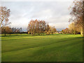
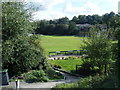
Golf course with birch trees
The fairways of the Whitefield Golf Club are separated by belts of trees, mostly Silver Birch. Low, afternoon light accentuates the contours of the ground and casts light onto the sides of the trees.
Image: © Jonathan Wilkins
Taken: 25 Dec 2013
0.13 miles
10
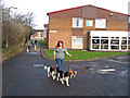
Top o'th Fields 1
A popular walking route between the 'Trees' estate and Fountain place shopping precinct runs along the boundary of the golf course. On the now traditional mid-day walk, the image was taken at 12:04h.
Image: © Jonathan Wilkins
Taken: 25 Dec 2013
0.14 miles