IMAGES TAKEN NEAR TO
The Fairways, MANCHESTER, M45 7BN
Introduction
This page details the photographs taken nearby to The Fairways, M45 7BN by members of the Geograph project.
The Geograph project started in 2005 with the aim of publishing, organising and preserving representative images for every square kilometre of Great Britain, Ireland and the Isle of Man.

There are currently over 7.5m images from over14,400 individuals and you can help contribute to the project by visiting https://www.geograph.org.uk
Image Map
Images are licensed for reuse under creativecommons.org/licenses/by-sa/2.0
Notes
- Clicking on the map will re-center to the selected point.
- The higher the marker number, the further away the image location is from the centre of the postcode.
Image Listing (63 Images Found)
Images are licensed for reuse under creativecommons.org/licenses/by-sa/2.0
Image
Details
Distance
1
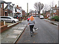
Midday walk, Pine Avenue
A break in the clouds gave an opportunity for a quick walk to the next square.
Image: © Jonathan Wilkins
Taken: 25 Dec 2012
0.08 miles
2
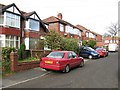
Pine Avenue
Part of an estate built in the 1930s and still presenting a homely, residential aspect.
Image: © Jonathan Wilkins
Taken: 26 Oct 2012
0.12 miles
4

Top o'th Fields 2
Top o'th Fields is a development of 30 warden-controlled, single-bedroom flats that was built in 1972. It is run by Six Town Housing, which is the property management 'arm's-length' company for all of Bury Councils' housing. Top o'th Fields is also the name of the road which runs across the frontage.
Image: © Jonathan Wilkins
Taken: 25 Dec 2013
0.14 miles
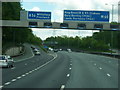
6
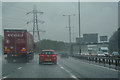
Whitefield : M60 Motorway
The M60 motorway between Junction 17 (Whitefield Interchange) and Junction 16.
Image: © Lewis Clarke
Taken: 27 Sep 2019
0.15 miles
7

Top o'th Fields 1
A popular walking route between the 'Trees' estate and Fountain place shopping precinct runs along the boundary of the golf course. On the now traditional mid-day walk, the image was taken at 12:04h.
Image: © Jonathan Wilkins
Taken: 25 Dec 2013
0.15 miles
9

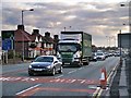
Eastbound on the M60 at Junction 17
Exceed Logistics MAN truck (MV61 XKX) passes under the A56 (Bury New Road) at Whitefield Interchange on the eastbound M60.
Image: © David Dixon
Taken: 24 Feb 2014
0.17 miles
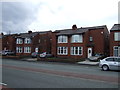
10
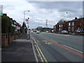
Besses o'th' Barn, Bury New Road (A56)
Image: © David Dixon
Taken: 24 Feb 2014
0.17 miles