IMAGES TAKEN NEAR TO
Victoria Lane, MANCHESTER, M45 6FF
Introduction
This page details the photographs taken nearby to Victoria Lane, M45 6FF by members of the Geograph project.
The Geograph project started in 2005 with the aim of publishing, organising and preserving representative images for every square kilometre of Great Britain, Ireland and the Isle of Man.

There are currently over 7.5m images from over14,400 individuals and you can help contribute to the project by visiting https://www.geograph.org.uk
Image Map
Images are licensed for reuse under creativecommons.org/licenses/by-sa/2.0
Notes
- Clicking on the map will re-center to the selected point.
- The higher the marker number, the further away the image location is from the centre of the postcode.
Image Listing (55 Images Found)
Images are licensed for reuse under creativecommons.org/licenses/by-sa/2.0
Image
Details
Distance
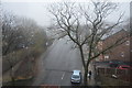
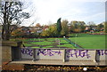
3
Victoria Park and Metrolink
Victoria Park forms an enclave to the east of Bury New Road. A bridge on the Metrolink line crosses a footpath route which parallels Victoria Lane.
Image: © Jonathan Wilkins
Taken: 27 Dec 2015
0.06 miles
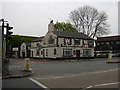
10

The Bee Hive Inn, Bury New Road
The building, at the corner of Victoria Lane and Bury New Road, is notable for the bee mural painted on the side wall (Image] and Image]).
Image: © David Dixon
Taken: 15 Jun 2020
0.13 miles